Here is the latest updates for TC Alfred. TROPICAL CYCLONE ADVICE NUMBER 4 Issued at 4:52 am EST on Tuesday 4 March 2025 Headline: Tropical Cyclone Alfred to turn towards the southeast Queensland coast today with a coastal impact later this week. Areas Affected: Warning Zone None. Watch Zone Sandy Cape to Grafton, including Brisbane, Gold Coast, Sunshine Coast, and Byron Bay but not including Grafton. Cancelled Zone None. Details of Tropical Cyclone Alfred 22U at 4:00 am AEST [5:00 am AEDT]: Intensity: Category 2, sustained winds near the centre of 95 kilometres per hour with wind gusts to 130 kilometres per hour. Location: within 30 kilometres of 27.1 degrees South 158.7 degrees East, estimated to be 560 kilometres east of Brisbane and 560 kilometres east of Maroochydore. Movement: south southeast at 6 kilometres per hour. Tropical Cyclone Alfred is currently moving southeast, but it is expected to slow and turn west towards the Queensland coast later today. Alfred's intensity may fluctuate between category 1 and 2 over the next few days, but it is forecast to cross the southeast Queensland coast at category 2 strength late on Thursday or early Friday morning.    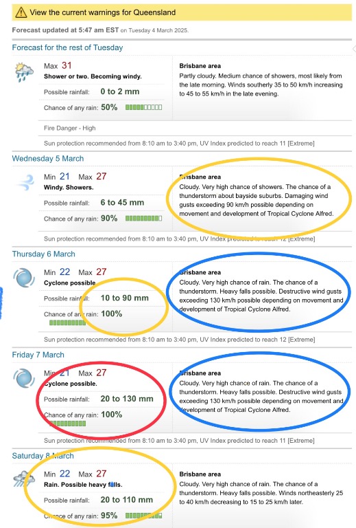  
|


|
|
Font Color
Font Size
|
|
Important Information:
The Weather Forum uses cookies. By continuing to browse this site, you are agreeing to our use of cookies.
More Details
Close
