Wednesday breakdown was based on Soundings and multiple models, GFS, EC, Icon and Access. I know I have posted these for Thursday but they were from the Wednesday run


Current long-range forecasts indicate a high likelihood of thunderstorms in Southeast Queensland and Northeast New South Wales (NSW) for Saturday, November 1, 2025. Forecasts suggest a potential for heavy thunderstorms, with warm temperatures and high humidity contributing to the stormy conditions.
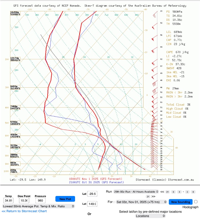
Outlook for Saturday, November 1, 2025
Southeast Queensland
Conditions: The forecast for Brisbane is for a heavy thunderstorm with a 50% chance of rain.
Temperatures: Temperatures in Brisbane are expected to reach a maximum of 26°C, with a low of 19°C.
Hazards: Storms may bring the potential for heavy rainfall, damaging winds, and large hail.
Northeast New South Wales
Conditions: Tweed Heads is forecast to have scattered thunderstorms, with a 35% chance of rain.
Temperatures: Tweed Heads is expected to see a maximum temperature of 25°C and a minimum of 19°C.
Hazards: Similar to Southeast Queensland, the storms could produce heavy rain, damaging winds, and large hail.
Broader factors influencing storm activity
Several factors are creating a favorable environment for thunderstorms in the region:
High ocean temperatures: Warmer-than-average sea surface temperatures are likely around Australia's east coast, which can increase moisture and energy for storms.
Surface trough: A surface-based trough is expected over the region, which will aid in moisture intrusion and help produce storms.
Climatic influences: A La Niña event combined with a negative Indian Ocean Dipole and a positive Southern Annular Mode, have been contributing to wetter-than-average conditions for eastern Australia.
Important considerations
Forecasts can change: Weather conditions can be volatile and difficult to predict far in advance, especially with thunderstorms. You should check the updated forecast closer to the date for the most accurate information.
Stay alert for warnings: With the potential for severe weather, it is recommended to stay up-to-date with the latest official weather warnings from BoM.
