Originally Posted by: FNQ Bunyip 
I'll kick this off as we now have T.C Fina North East of Darwin ...
Cheers
Thanks Bunyip. Pressed the wrong thread button on my phone getting into here too... Heres this morning's track map from 04:11am. Next one at 10:30 ACST. (or is it CST? BOM can't make up it's mind.) 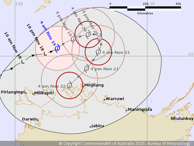 Tropical Cyclone Fina has formed north of Darwin and is moving slowly to the east northeast away from the coast. Area affected Warning zone None. Watch zone None. Cancelled zone None. At 3:30 am Australian Central Standard Time At 3:30 am ACST Intensity category 1, sustained winds near the centre of 75 kilometres per hour with wind gusts to 100 kilometres per hour Location within 35 kilometres of 9.7 degrees South, 131.6 degrees East, 315 kilometres north northeast of Darwin and 195 kilometres north northwest of Minjilang Movement east northeast at 9 kilometres per hour TC Fina is expected to continue moving to the east northeast and intensify to Category 2 by Wednesday night. Later on Thursday it should turn to the south then southwest, taking it towards the Northern Territory coast for a potential impact during Friday and Saturday. Hazards Communities over the Northern Territory are not expected to be impacted within the next 48 hours by Tropical Cyclone Fina. Recommended action NTES advices for residents to follow the directions of emergency services.
|


|
|
Font Color
Font Size
|
|
Important Information:
The Weather Forum uses cookies. By continuing to browse this site, you are agreeing to our use of cookies.
More Details
Close
