Weather Forum
»
Australia Weather
»
Victoria
»
Victoria - Day to Day Weather
Rank: Administration
Groups: Administrators
Joined: 9/08/2019(UTC)
Posts: 70
Thanks: 151 times
Was thanked: 98 time(s) in 41 post(s)
|
Welcome to the Victoria - Day to Day Weather forum! Edited by user Sunday, 25 August 2019 7:20:14 AM(UTC)
| Reason: Not specified
|
|
|
|
|
|
Rank: Newbie
Groups: Registered
Joined: 22/08/2019(UTC) Posts: 2  Location: Woodend VIC 579 ASL Was thanked: 2 time(s) in 1 post(s)
|
Chilly breezy day today with a high of 9.8c. If it clears up tonight and the wind can relax (tough with a southerly gradient at my locale) we may have a pretty good frost.
|
|
|
|
|
|
Rank: Member
Groups: Registered
Joined: 23/08/2019(UTC) Posts: 21  Location: St. Kilda Thanks: 32 times
Was thanked: 30 time(s) in 19 post(s)
|
I woke up excited today to see a forecast high of 17°C. 1pm and it is 13.8°C and windy. 
|
|
|
|
|
|
Rank: Advanced Member
Groups: Registered
Joined: 24/08/2019(UTC) Posts: 292  Location: Country Victorian Thanks: 580 times
Was thanked: 503 time(s) in 194 post(s)
|
Hi 'guys'. I have property in central west VIC and like to keep an eye on the weather down there. Went down a few weeks ago,and it was very green in the west. Quite nice actually because many others area of OZ are stillvery dry. Anyway it appear yet another trough and front for VIC.. Here are a few notes on this incoming system l have taken from my blog. I look forward to reading your posts and contributing here..cheers ..... 'Another westerly belt trough for VIC, wednesday the 28th Aug 2019A precipitation signal from ACC r. The front arrives on wednesday about 10pm. The mslp is a curious 1020 hPa as the front hits the Victorian south west coast in the evening. The front and trough migrate across VIC on thursday picking up extra moisture from a low off NE Tassie’ which looks to wrap up some tropical moisture streaming down from the northern coral sea. This benefits east VIC on thursday with enhanced rainfall and should l dare suggest' thunderstorm activity. http://www.bom.gov.au/au...harts/viewer/index.shtml
|
|
|
|
|
|
Rank: Advanced Member
Groups: Registered
Joined: 24/08/2019(UTC) Posts: 292  Location: Country Victorian Thanks: 580 times
Was thanked: 503 time(s) in 194 post(s)
|
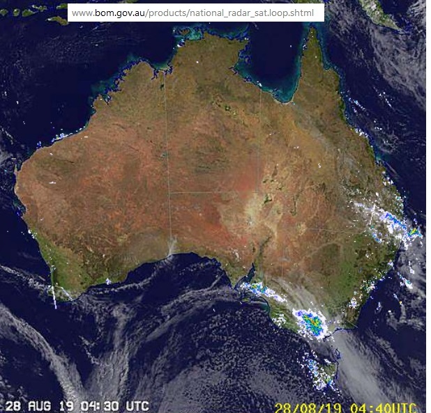
Incoming cold front and westerly belt is seen on satellite this morning. Good call re timing from ACC g Front in the west of the state for most of the day. Reaches Melbourne about lunchtime. A possible storm line embedded in a well defined front line. Front and trough line passes through east VIC this afternoon and evening. Reminder to check radar and storm tracker for VIC today http://www.bom.gov.au/au...harts/viewer/index.shtmlEdited by user Wednesday, 28 August 2019 8:14:34 AM(UTC)
| Reason: Not specified
|
|
|
|
|
|
Rank: Advanced Member
Groups: Registered
Joined: 23/08/2019(UTC) Posts: 59  Location: Sydney Thanks: 88 times
Was thanked: 88 time(s) in 40 post(s)
|
Sure is great to see us getting some late winter rains and thank you for posting the information.
|
|
|
|
|
|
Rank: Advanced Member
Groups: Registered
Joined: 24/08/2019(UTC) Posts: 292  Location: Country Victorian Thanks: 580 times
Was thanked: 503 time(s) in 194 post(s)
|
Yes 'nodrops' .,There is some BOM data in now showing all regions where the front and troughing have been have got something. Nice to see another widespread event. This top up will just add to the already good totals on the west of the state. The farmers will be happy with a promising harvest this summer ...... up until 5.30pm the range in totals by area.. 28th Aug 2019 Mallee ..0 - 4.2 mm Wimmera. 1.6 -2.4mm south west..8.8.mm central 1.8 to 10.2 mm The rain band moving through north and east of the state now and into the evening http://www.bom.gov.au/vi...ons/vicall.shtml?ref=hdr
|
|
|
|
|
|
Rank: Advanced Member
Groups: Registered
Joined: 24/08/2019(UTC) Posts: 292  Location: Country Victorian Thanks: 580 times
Was thanked: 503 time(s) in 194 post(s)
|
Originally Posted by: crikey  Yes 'nodrops' .,There is some BOM data in now showing all regions where the front and troughing have been have got something. Nice to see another widespread event. This top up will just add to the already good totals on the west of the state. The farmers will be happy with a promising harvest this summer ...... up until 5.30pm the range in totals by area.. 28th Aug 2019 Mallee ..0 - 4.2 mm Wimmera. 1.6 -2.4mm south west..8.8.mm central 1.8 to 10.2 mm The rain band moving through north and east of the state now and into the evening http://www.bom.gov.au/vi...ons/vicall.shtml?ref=hdr Looks like everyone got something http://www.bom.gov.au/vic/flood/index.shtml http://www.bom.gov.au/vic/flood/index.shtml
|
|
|
|
|
|
Rank: Advanced Member
Groups: Registered
Joined: 31/08/2019(UTC) Posts: 38  Location: Victoria Thanks: 59 times
Was thanked: 40 time(s) in 19 post(s)
|
Good job Paul. The forum is looking great. I am ex weatherzoner . I just want to say l support what your doing here and good luck in your new venture.
Weatherzone reporting for the end of August.Always like their news clips.  At least the report is not above average for changehttps://www.weatherzone....ust-for-melbourne/530154The temperature and rainfall were close to the long term average across the month of August in Victoria's capital. At least the report is not above average for changehttps://www.weatherzone....ust-for-melbourne/530154The temperature and rainfall were close to the long term average across the month of August in Victoria's capital.'Melbourne Olympic Park's rain guage collected 51.4mm, compared to the August average of 50mm. The combined mean maximum and minimum temperature across the month was within a tenth of a degree of the long term average of 10.8 degrees. Although, the average minimum temperature was around 0.7 degrees above average, the average maximum temperature was 0.5 degrees below average. Slightly above average cloud cover was the main driver of the warmer than average nights and marginally colder than average days. August 2018 and 2017 were also quite close to the long term average in terms of temperatures and rainfall.'>>>>>>. August 3yrs in a row average ,to coincide with the average snow falls we have had these past 3yrs?..Intriguing
|
|
|
|
|
|
Rank: Advanced Member
Groups: Registered
Joined: 31/08/2019(UTC) Posts: 38  Location: Victoria Thanks: 59 times
Was thanked: 40 time(s) in 19 post(s)
|
Front and storm line has passed through Melbourne. Perth and Melbourne going off at the same time on this shot Rain totals quite humble 0 to 5mm mostly   Edited by user Sunday, 1 September 2019 6:13:48 PM(UTC)
| Reason: Not specified
|
|
|
|
|
|
Rank: Member
Groups: Registered
Joined: 23/08/2019(UTC) Posts: 21  Location: St. Kilda Thanks: 32 times
Was thanked: 30 time(s) in 19 post(s)
|
Thanks WhiskeyZulu2, yep, cold and wet here. Totally ruined our planned Father's Day lunch, but that is life I guess. Currently 12 degrees and drizzle outside.
Things look like they will warm up tomorrow, which is good. Roll on warmer weather.
|
 1 user thanked StKildaClare for this useful post.
|
|
|
|
Rank: Advanced Member
Groups: Registered
Joined: 31/08/2019(UTC) Posts: 38  Location: Victoria Thanks: 59 times
Was thanked: 40 time(s) in 19 post(s)
|
|
 2 users thanked whiskyzulu2 for this useful post.
|
|
|
|
Rank: Advanced Member
Groups: Registered
Joined: 25/08/2019(UTC) Posts: 1,839  Location: Ferny Grove Thanks: 985 times
Was thanked: 856 time(s) in 419 post(s)
|
Weather report removed, I posted to the wrong thread, should be the NE NSW and SE QLD thread. This weather report now in correct thread Edited by user Monday, 2 September 2019 12:37:34 PM(UTC)
| Reason: Posted in wrong thread |
|
 1 user thanked Falling_Droplet for this useful post.
|
|
|
|
Rank: Advanced Member
Groups: Registered
Joined: 24/08/2019(UTC) Posts: 292  Location: Country Victorian Thanks: 580 times
Was thanked: 503 time(s) in 194 post(s)
|
Whoo Hoo . Some action on the dartboard from ACC g. Here are my notes out of the starting gate  cheers Cut off low from the westerly belt forms around Friday 5th of September and intensifies into the 6th and 7th. (weekend)
This system is likely to affect SE SA, ALL of VIC and many parts of NSW.
ACC g also has it forming an ECL off the coast of NSW.
So a widespread event and something to chatter about for those living in SE OZ
 source http://www.bom.gov.au/au...harts/viewer/index.shtml
|
 1 user thanked crikey for this useful post.
|
|
|
|
Rank: Advanced Member
Groups: Registered
Joined: 31/08/2019(UTC) Posts: 38  Location: Victoria Thanks: 59 times
Was thanked: 40 time(s) in 19 post(s)
|
Yet another rain band passing through west Vic. Small totals but handy. Horsham up to 2mm
|
 1 user thanked whiskyzulu2 for this useful post.
|
|
|
|
Rank: Member
Groups: Registered
Joined: 23/08/2019(UTC) Posts: 21  Location: St. Kilda Thanks: 32 times
Was thanked: 30 time(s) in 19 post(s)
|
A small and tantalizing glimpse of Spring tomorrow and then back to horrible weather.  Forecast for this week. 
|
 1 user thanked StKildaClare for this useful post.
|
|
|
|
Rank: Advanced Member
Groups: Registered
Joined: 31/08/2019(UTC) Posts: 38  Location: Victoria Thanks: 59 times
Was thanked: 40 time(s) in 19 post(s)
|
Originally Posted by: StKildaClare  A small and tantalizing glimpse of Spring tomorrow and then back to horrible weather.  Forecast for this week.  Looks like a bit of showery patchy stuff coming in from the west tomorrow, wednesday about lunchtime, from the west. Some will miss out completely. Edited by user Tuesday, 3 September 2019 1:49:04 PM(UTC)
| Reason: Not specified
|
|
|
|
|
|
Rank: Advanced Member
Groups: Registered
Joined: 24/08/2019(UTC) Posts: 292  Location: Country Victorian Thanks: 580 times
Was thanked: 503 time(s) in 194 post(s)
|
ACC g continues to see this cut off low as a significant rain event for Victoria.
This picture is for 4pm diurnal max.
|
 1 user thanked crikey for this useful post.
|
|
|
|
Rank: Member
Groups: Registered
Joined: 23/08/2019(UTC) Posts: 21  Location: St. Kilda Thanks: 32 times
Was thanked: 30 time(s) in 19 post(s)
|
This weather is horrible and what a great forecast.
Today - Rain
Wed - Rain
Thurs - Rain
Fri - Rain
Sat - Rain
I wonder if NotCrocDundee would like to house swap for a few weeks?
|
 2 users thanked StKildaClare for this useful post.
|
|
|
|
Rank: Advanced Member
Groups: Registered
Joined: 31/08/2019(UTC) Posts: 38  Location: Victoria Thanks: 59 times
Was thanked: 40 time(s) in 19 post(s)
|
Thanks for that 'clare l haven't had time to check the forecast today. A stream of cold showers coming through Geelong , Ballarat and central district this evening . Mildura hit the highest at about 25deg c Ballarat top of 15. Is it my imagination . Don’t we usually get a few warmer days in the last 2 weeks of winter ?. I must find some time to check the records. Looks like a hit and miss thing here. Speckled radar 
|
 1 user thanked whiskyzulu2 for this useful post.
|
|
|
|
Weather Forum
»
Australia Weather
»
Victoria
»
Victoria - Day to Day Weather
Forum Jump
You cannot post new topics in this forum.
You cannot reply to topics in this forum.
You cannot delete your posts in this forum.
You cannot edit your posts in this forum.
You cannot create polls in this forum.
You cannot vote in polls in this forum.
Important Information:
The Weather Forum uses cookies. By continuing to browse this site, you are agreeing to our use of cookies.
More Details
Close

