Weather Forum

Welcome Guest! To enable all features please Login or Register.

Notification

Icon
Error

2 Pages12>
Share
Options
Go to last post Go to first unread
Offline Ken  
#1 Posted : Sunday, 3 November 2019 2:39:53 PM(UTC)
Ken

Rank: Advanced Member

Groups: Registered
Joined: 2/09/2019(UTC)
Posts: 105
Australia
Location: Brisbane

Thanks: 145 times
Was thanked: 561 time(s) in 103 post(s)
UserPostedImage

UserPostedImage

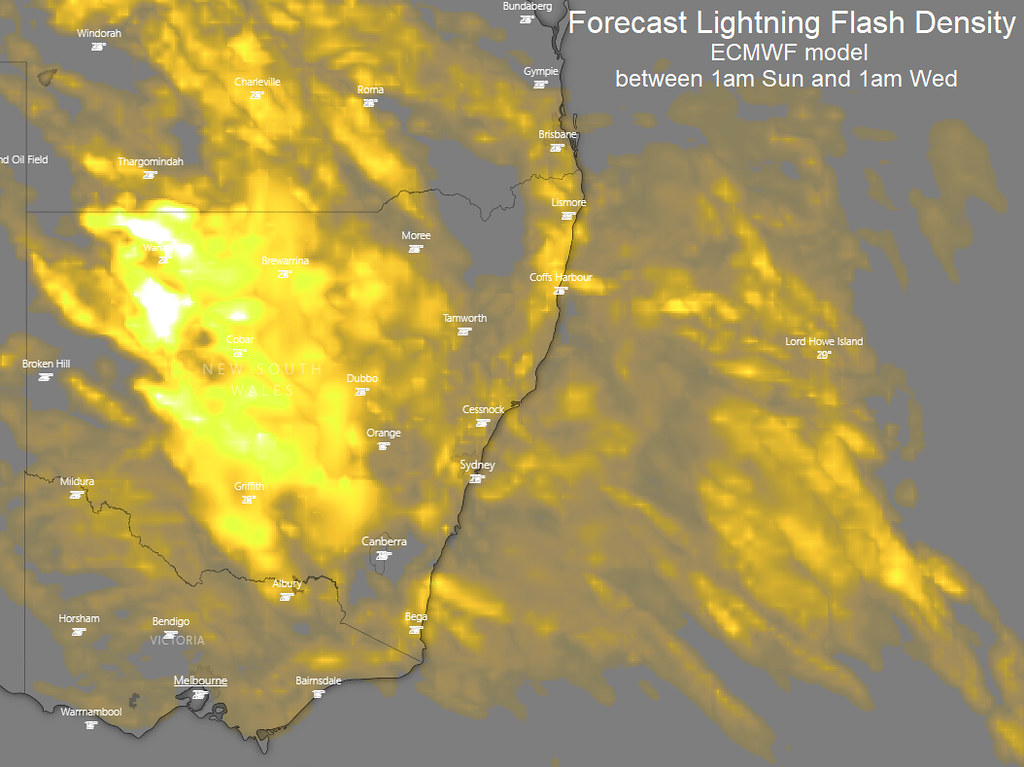
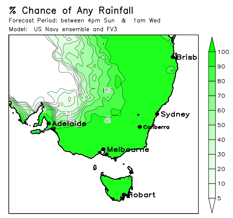
Still looks to me like the majority of locations in our region will probably get some shower and/or storm action out of the setup on Monday (with some heavier falls for those who get storms), and perhaps also near or south of the border on Tuesday.... but there's still some uncertainties that warrant caution about extent/severity, namely if any morning cloud or precip on Monday from inland will affect things later on, and the very marginal setup on Tuesday as far as SE QLD goes.

Strong gusty W to SW winds developing on Tuesday during the middle of the day and afternoon especially about higher ground inland behind the front, as well as the strong southerlies about the islands and coastal fringe behind the coastal component of the change also.

Here’s how I think things will play out (I've mainly focused on SE QLD here since I haven't had much time to look at NE NSW in great detail) as a front, surface and a couple of upper troughs approach:

1️⃣ From late Sunday afternoon through the overnight hours, a band of showers/storms gradually makes its way across the Downs.
2️⃣ Monday morning has a bit of uncertainty about how little or much the inland activity reaches SE QLD.
A fair bit of cloud cover and some patchy decaying remains of the inland activity may reach the eastern Downs/some locations in SE QLD in the early morning hours ahead of the initial decaying upper trough, but you can never tell for sure with these things
(e.g. if inland steering winds aloft are strong enough, more extensive activity may reach SE QLD… conversely, if the remains weaken too early, they may struggle to even reach the eastern Downs or SE QLD, or it may be late morning even if they do at all).
3️⃣ Monday afternoon and night therefore also has a bit of uncertainty depending on what happens in point #2 above. The more favoured scenario is for a good band of showers/storms redeveloping inland before marching east into SE QLD in the afternoon or at night, although there’s a bit of a question mark over the timing/duration/extent of this activity. Some scenarios are as early as just after lunchtime while some delay it to the late night-time hours depending on location.
Although the majority of places currently look likely to get at least something out of this and a few locations may also get a severe storm (with intense rainfall, brief damaging winds, or large hail), the extent of storms as well as severe storms will depend on what happens in the morning.
If there’s more cloud cover and rainfall than expected in the morning, less locations are likely to be affected by a storm later on, and severe storms become less likely. On the other hand, if there’s less cloud cover and rainfall than expected, it only takes a few clearer gaps that last for a few hours to allow enough heating for numerous storms to develop, some severe (due to the strong shear and some turning in the lower levels near the coast with the NNE seabreeze effect).
4️⃣ Tuesday looks mainly dry north of the border but it still has a bit of uncertainty.
At this stage, the more favoured scenario is for the majority of any remaining overnight shower/storm activity to clear the area before dawn leaving most of the day dry (because a drier NW wind flow kicks in before becoming even drier W to SW winds during the middle of the day before the coastal change surges through)... with most of the activity confined to areas south of the border.
But if there’s more moisture than expected, there’s the slight risk of some additional (but more localised) shower or severe storm activity redeveloping, helped by the sharpening strong upper trough, strong shear and steering winds..... although even if this were to happen, it’d be mainly confined to southern parts of SE QLD and more likely near, and south of the QLD/NSW border. But if it’s too dry, nothing will form except for south of the border.
5️⃣ Strong gusty W to SW winds developing on Tuesday during the middle of the day and afternoon especially about higher ground inland behind the front, as well as the strong southerlies about the islands and coastal fringe behind the coastal component of the change also.

So basically looks like a case of a least something for most people unless you're unlucky... but due to the convective nature of the rainfall, some will probably get a lot while some won't.

Looking very hot later this week too, especially away from the coast with little or no rainfall after the upcoming activity.

Above are some graphics (I'm not sure I'd treat that hole in the lightning activity on the first map too literally - depends a lot on how far east the initial inland activity can make it).
thanks 8 users thanked Ken for this useful post.
Tsunami on 3/11/2019(UTC), CantSpellNarangba on 3/11/2019(UTC), SatMan on 3/11/2019(UTC), DelBoy on 3/11/2019(UTC), Pabloako on 3/11/2019(UTC), juztchillin on 3/11/2019(UTC), crikey on 3/11/2019(UTC), Falling_Droplet on 4/11/2019(UTC)
Offline Tsunami  
#2 Posted : Sunday, 3 November 2019 3:24:14 PM(UTC)
Tsunami

Rank: Advanced Member

Groups: Registered
Joined: 27/08/2019(UTC)
Posts: 47
Australia
Location: Bayside

Thanks: 51 times
Was thanked: 104 time(s) in 35 post(s)
Thanks Ken
Been waiting for your take on the set up
Will those old school storms ever occur again
The ones that came without fail late arvos
thanks 4 users thanked Tsunami for this useful post.
Ken on 3/11/2019(UTC), juztchillin on 3/11/2019(UTC), crikey on 3/11/2019(UTC), Falling_Droplet on 4/11/2019(UTC)
Offline CantSpellNarangba  
#3 Posted : Sunday, 3 November 2019 4:47:16 PM(UTC)
CantSpellNarangba

Rank: Advanced Member

Groups: Registered
Joined: 23/08/2019(UTC)
Posts: 155
Australia
Location: Narangba

Thanks: 280 times
Was thanked: 442 time(s) in 136 post(s)
Great stuff Ken. Thank you for starting the thread! ThumpUp
I tried starting one a couple of times, but couldn't string a sentence together that showed that I had half a brain cell and knew what I was talking about.

Great to see inland areas getting some rain too, especially NSW!
thanks 4 users thanked CantSpellNarangba for this useful post.
juztchillin on 3/11/2019(UTC), crikey on 3/11/2019(UTC), Ken on 4/11/2019(UTC), Falling_Droplet on 4/11/2019(UTC)
Offline DelBoy  
#4 Posted : Sunday, 3 November 2019 4:56:47 PM(UTC)
DelBoy

Rank: Advanced Member

Groups: Registered
Joined: 13/09/2019(UTC)
Posts: 118
Location: Caboolture (the next Las Vegas!)

Thanks: 215 times
Was thanked: 297 time(s) in 100 post(s)
Originally Posted by: CantSpellNarangba Go to Quoted Post


Great to see inland areas getting some rain too, especially NSW!


Looking around the BOM map, there our some places in NW NSE (Outside this area, but hey, I will post them anyway...)
Gumbooka - 49mm
Knightsvale - 26mm
Okeh - 16mm
Wanaaring - 27mm

In SW QLD
Hungerford - 10mm
Eromanga - 12mm
Windorah - 3mm

Probably the most the cow cockies out that way have seen for months
thanks 4 users thanked DelBoy for this useful post.
juztchillin on 3/11/2019(UTC), crikey on 3/11/2019(UTC), Ken on 4/11/2019(UTC), Falling_Droplet on 4/11/2019(UTC)
Offline Pabloako  
#5 Posted : Sunday, 3 November 2019 5:10:47 PM(UTC)
Pabloako

Rank: Advanced Member

Groups: Registered
Joined: 21/08/2019(UTC)
Posts: 185
Australia
Location: Ocean View

Thanks: 359 times
Was thanked: 539 time(s) in 161 post(s)
Thank you for starting the new thread Ken!

This is how GFS things the event will play out over the next couple of days...

GFS 3-11 to 5-11
thanks 4 users thanked Pabloako for this useful post.
juztchillin on 3/11/2019(UTC), crikey on 3/11/2019(UTC), Ken on 4/11/2019(UTC), Falling_Droplet on 4/11/2019(UTC)
Offline juztchillin  
#6 Posted : Sunday, 3 November 2019 7:12:40 PM(UTC)
juztchillin

Rank: Advanced Member

Groups: Registered
Joined: 21/09/2019(UTC)
Posts: 32
Australia
Location: Gold coast

Thanks: 125 times
Was thanked: 126 time(s) in 31 post(s)
BOM forecast for the Gold coast tomorrow pretty tame.

Monday 4 November

Summary
Min 18
Max 27
Shower or two.
Possible rainfall: 2 to 4 mm
Chance of any rain: 60%

Gold Coast area

Cloudy. High (70%) chance of showers, most likely in the afternoon and evening. The chance of a thunderstorm from the late morning. Winds north to northwesterly 15 to 25 km/h.


This satellite picture gives some indication on whats coming tomorrow.

3rd nov19 trough.jpg
thanks 2 users thanked juztchillin for this useful post.
Ken on 4/11/2019(UTC), Falling_Droplet on 4/11/2019(UTC)
Offline crikey  
#7 Posted : Sunday, 3 November 2019 7:51:15 PM(UTC)
crikey

Rank: Advanced Member

Groups: Registered
Joined: 24/08/2019(UTC)
Posts: 292
Australia
Location: Country Victorian

Thanks: 580 times
Was thanked: 503 time(s) in 194 post(s)
ACCESS r has a strong precip' signal west of the divide around midnight tonight and into the early hours of tomorrow morning( 2 to 5 am)
This signal weakens approaching the coast overnight but reaches the coast around 5am tomorrow morning .

High pressure isobars then weaken the trough early tomorrow but the trough is re defined later in the day.

This snap below is the 2pm forecast giving any goods to north of the border

4 nov 19 seq trough.jpg

source
http://www.bom.gov.au/au...harts/viewer/index.shtml
thanks 3 users thanked crikey for this useful post.
CantSpellNarangba on 3/11/2019(UTC), Ken on 4/11/2019(UTC), Falling_Droplet on 4/11/2019(UTC)
Offline DelBoy  
#8 Posted : Sunday, 3 November 2019 9:09:19 PM(UTC)
DelBoy

Rank: Advanced Member

Groups: Registered
Joined: 13/09/2019(UTC)
Posts: 118
Location: Caboolture (the next Las Vegas!)

Thanks: 215 times
Was thanked: 297 time(s) in 100 post(s)
Slowly marching eastwards. (Almost like waiting for Christmas as a kid... One more sleep to go!)

IDR00004.jpg

Good to see NSW get a drink.
thanks 2 users thanked DelBoy for this useful post.
Ken on 4/11/2019(UTC), Falling_Droplet on 4/11/2019(UTC)
Offline Ken  
#9 Posted : Monday, 4 November 2019 12:31:45 AM(UTC)
Ken

Rank: Advanced Member

Groups: Registered
Joined: 2/09/2019(UTC)
Posts: 105
Australia
Location: Brisbane

Thanks: 145 times
Was thanked: 561 time(s) in 103 post(s)
Originally Posted by: CantSpellNarangba Go to Quoted Post
Great stuff Ken. Thank you for starting the thread! ThumpUp
I tried starting one a couple of times, but couldn't string a sentence together that showed that I had half a brain cell and knew what I was talking about.

Great to see inland areas getting some rain too, especially NSW!

I can’t blame you. I was actually reluctant to bother creating a new thread myself because it’s hard to articulate the complex differing timings of the upcoming activity on top of the uncertainties of those timings and their potential knock on effects.
I definitely can’t see it being any kind of exceptional event overall but something’s better than nothing I guess.


thanks 2 users thanked Ken for this useful post.
DelBoy on 4/11/2019(UTC), Falling_Droplet on 4/11/2019(UTC)
Offline Tsunami  
#10 Posted : Monday, 4 November 2019 10:16:19 AM(UTC)
Tsunami

Rank: Advanced Member

Groups: Registered
Joined: 27/08/2019(UTC)
Posts: 47
Australia
Location: Bayside

Thanks: 51 times
Was thanked: 104 time(s) in 35 post(s)
Sun is out now. Plenty of heating going on yip yip
Offline Tsunami  
#11 Posted : Monday, 4 November 2019 12:35:17 PM(UTC)
Tsunami

Rank: Advanced Member

Groups: Registered
Joined: 27/08/2019(UTC)
Posts: 47
Australia
Location: Bayside

Thanks: 51 times
Was thanked: 104 time(s) in 35 post(s)
Feels hot enough
Radar showed sime activity but has desolved
Weather station just showing cloud
Offline Ken  
#12 Posted : Monday, 4 November 2019 6:10:16 PM(UTC)
Ken

Rank: Advanced Member

Groups: Registered
Joined: 2/09/2019(UTC)
Posts: 105
Australia
Location: Brisbane

Thanks: 145 times
Was thanked: 561 time(s) in 103 post(s)
UserPostedImage

UserPostedImage

Being cautious about thunderstorm forecasts and emphasising any significant uncertainties can really pay dividends when not all the stars are aligned.

The 3pm satpic above via Weatherzone shows the localised showers & thunderstorms that formed in parts of SE QLD and moved in an E to ENE direction.

Apart from some potential inhibiting effect from the morning cloud mentioned in yesterday’s post, data from this morning's observed sounding from Brisbane Airport also showed a noticeable temperature inversion in the middle levels of the atmosphere (see 1st image above).
This is likely to be one of the significant factors in keeping shower/storm activity fairly localised. The general “flattening out” type of visual appearance of some of the towering cumulus clouds on webcams as they try to grow taller looks consistent with that.
thanks 1 user thanked Ken for this useful post.
Falling_Droplet on 4/11/2019(UTC)
Offline DelBoy  
#13 Posted : Monday, 4 November 2019 6:32:06 PM(UTC)
DelBoy

Rank: Advanced Member

Groups: Registered
Joined: 13/09/2019(UTC)
Posts: 118
Location: Caboolture (the next Las Vegas!)

Thanks: 215 times
Was thanked: 297 time(s) in 100 post(s)
Well, that didn't quite work here. No drops of rain here and no rumbles. Oh well. That's life
thanks 1 user thanked DelBoy for this useful post.
Falling_Droplet on 4/11/2019(UTC)
Offline SatMan  
#14 Posted : Monday, 4 November 2019 6:45:48 PM(UTC)
SatMan

Rank: Advanced Member

Groups: Registered
Joined: 7/09/2019(UTC)
Posts: 67
Australia
Location: Brisbane

Thanks: 113 times
Was thanked: 207 time(s) in 61 post(s)
A couple of drops here literally and that is it. Confused

thanks 1 user thanked SatMan for this useful post.
Falling_Droplet on 4/11/2019(UTC)
Offline Falling_Droplet  
#15 Posted : Monday, 4 November 2019 7:52:33 PM(UTC)
Falling_Droplet

Rank: Advanced Member

Groups: Registered
Joined: 25/08/2019(UTC)
Posts: 1,839
Australia
Location: Ferny Grove

Thanks: 985 times
Was thanked: 856 time(s) in 419 post(s)
I am a bit disappointed with today, only a few drops from a nearby shower. I thought that I might get something, but I wasn't too hopeful after looking at this morning sounding.

A warm today with a maximum of 33.7 C and the temperature was variable from mid morning to mid afternoon. Dew point was stable and near average at around 15 C which rose to 19 C earlier in the afternoon. The dew point have remained stable at 18 C for the last few hours. Near average relative humidity today falling to a low of 35%. Light NW to NE winds this morning with some E to NE winds, variable in the late morning and early afternoon, E to SE in the afternoon and E to NE later in the afternoon and N to NE tonight.
Offline Pabloako  
#16 Posted : Monday, 4 November 2019 8:12:18 PM(UTC)
Pabloako

Rank: Advanced Member

Groups: Registered
Joined: 21/08/2019(UTC)
Posts: 185
Australia
Location: Ocean View

Thanks: 359 times
Was thanked: 539 time(s) in 161 post(s)
Nothing here this afternoon, although it did look promising for a while, but fizzled out before it got here.

I did receive 0.8mm at 3am this morning those from a small shower.
Offline Tsunami  
#17 Posted : Monday, 4 November 2019 10:22:59 PM(UTC)
Tsunami

Rank: Advanced Member

Groups: Registered
Joined: 27/08/2019(UTC)
Posts: 47
Australia
Location: Bayside

Thanks: 51 times
Was thanked: 104 time(s) in 35 post(s)
Wow u really like this site
Went looking to see all posts in skincom.au
Cant figure
Offline Falling_Droplet  
#18 Posted : Monday, 4 November 2019 10:46:45 PM(UTC)
Falling_Droplet

Rank: Advanced Member

Groups: Registered
Joined: 25/08/2019(UTC)
Posts: 1,839
Australia
Location: Ferny Grove

Thanks: 985 times
Was thanked: 856 time(s) in 419 post(s)
Offline Falling_Droplet  
#19 Posted : Tuesday, 5 November 2019 8:14:26 AM(UTC)
Falling_Droplet

Rank: Advanced Member

Groups: Registered
Joined: 25/08/2019(UTC)
Posts: 1,839
Australia
Location: Ferny Grove

Thanks: 985 times
Was thanked: 856 time(s) in 419 post(s)

Ferny Grove Weather
Date: 5 Nov 2019
Time: 7:55 AM

Min Temp since 9am yesterday: 19.1 C
Max Temp since 9am yesterday: 33.7 C
Min Ground Temp: 18 C
Rain since 9am yesterday: 0 mm

Temperature: 26.8 C
Relative Humidity: 29 %
Dew Point: 7.3 C
MSL Pressure: 1012.1 hPa
Wind Speed: 12 kph - light breeze
Wind Direction: WNW

Present Weather: No cloud development observed
Visibility: 20km to 39km - Very Good Visibility
Cloud Cover: 0/8
Ground State: Ground dry

Notes of yesterday weather - 4/11/19: Cloudy periods becoming partly cloudy in the afternoon with ci, sc and ac clouds. A warm day with variable temperature from mid-morning to mid-afternoon. Dew point was stable and near average before rising during the early afternoon, stabilised during the afternoon and then slowly fell from late afternoon. Light N to NE winds became NW to NE later in the morning with some E to NE winds, variable winds in the late morning and afternoon, becoming E to SE in the early afternoon, E to NE from mid afternoon with also some N to NE winds in the evening and calm in the late evening.

Today: Minimum temperature reached at 1:30am before generally rising thereafter. Dew point fell in the early hours of today as the temperature rose and became moderately low. In the last few hours the dew point have been stable. Relative humidity fell and have become low and was rather variable in the early hours of today. Mostly light and increasing and a little gusty W to NW winds today.
Offline Ken  
#20 Posted : Tuesday, 5 November 2019 9:31:45 AM(UTC)
Ken

Rank: Advanced Member

Groups: Registered
Joined: 2/09/2019(UTC)
Posts: 105
Australia
Location: Brisbane

Thanks: 145 times
Was thanked: 561 time(s) in 103 post(s)
Originally Posted by: Tsunami Go to Quoted Post
Wow u really like this site
Went looking to see all posts in skincom.au
Cant figure

I had to re-read your sentence a few times to finally work out what you meant by skincom.au lol
Users browsing this topic
Guest (3)
2 Pages12>
Forum Jump  
You cannot post new topics in this forum.
You cannot reply to topics in this forum.
You cannot delete your posts in this forum.
You cannot edit your posts in this forum.
You cannot create polls in this forum.
You cannot vote in polls in this forum.

Weather Forum

Weatherzone Forum Alternative

The Weather Forum for Australia

Australian Weather Forum

Weather Forum for Australia, climate change, storm chasing, cyclones, weather photography