Weather Forum
»
Australia Weather
»
SEQ and NE NSW
»
SE QLD and NE NSW - Day to day Weather 2025
Rank: Advanced Member
Groups: Registered
Joined: 13/03/2024(UTC) Posts: 161  Location: South East Qld Thanks: 457 times
Was thanked: 152 time(s) in 149 post(s)
|
Just took this photo of the storm brewing to the North West of us. 
|
 2 users thanked Aussie Girl for this useful post.
|
|
|
|
Rank: Advanced Member
Groups: Registered
Joined: 13/03/2024(UTC) Posts: 161 Location: South East Qld Thanks: 457 times
Was thanked: 152 time(s) in 149 post(s)
|
An updated Severe Thunderstorm Warning from 3.08pm showing five storms.  The radar image from 3.30pm. 
|
|
|
|
|
|
Rank: Advanced Member
Groups: Registered, Administrators Joined: 21/08/2019(UTC) Posts: 941 Location: Brisbane Northside Thanks: 1198 times
Was thanked: 1136 time(s) in 674 post(s)
|
 The Bureau of Meteorology warns that, at 3:35 pm, severe thunderstorms likely to produce damaging winds, large hailstones and heavy rainfall that may lead to flash flooding were detected near Proston, the area south of Kingaroy, Springbrook, the area west of Kingaroy, Wynnum and Moogerah. These thunderstorms are moving towards the east to northeast. They are forecast to affect Coolangatta, Cleveland and Kingaroy by 4:05 pm and Beaudesert, the area northeast of Kingaroy and Canungra by 4:35 pm. 3-4 cm hail was reported at Bardon at about 3:30pm 2-3 cm hail was reported at Milton at 3:25pm |
Colin Maitland. |
1 user thanked Colmait for this useful post.
|
|
|
|
Rank: Advanced Member
Groups: Registered, Administrators Joined: 21/08/2019(UTC) Posts: 941 Location: Brisbane Northside Thanks: 1198 times
Was thanked: 1136 time(s) in 674 post(s)
|
These are rapid and gusty storms. Latest STW. We just had one form right above us and have some solid booms going off.  |
Colin Maitland. |
1 user thanked Colmait for this useful post.
|
|
|
|
Rank: Advanced Member
Groups: Registered, Administrators Joined: 21/08/2019(UTC) Posts: 941 Location: Brisbane Northside Thanks: 1198 times
Was thanked: 1136 time(s) in 674 post(s)
|
Finally getting a couple of cells colliding and at the rear another pushing through, so it looks like we may have a decent chunky storm. It is the storm to the North on the 64K radar  |
Colin Maitland. |
1 user thanked Colmait for this useful post.
|
|
|
|
Rank: Advanced Member
Groups: Registered, Administrators Joined: 21/08/2019(UTC) Posts: 941 Location: Brisbane Northside Thanks: 1198 times
Was thanked: 1136 time(s) in 674 post(s)
|
Starting to back build now as it interacts with the Seabreeze. Springbrook looks like it is about to get a bit of belting unfortunately with the cell heading straight towards it. 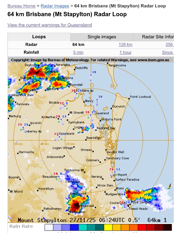 |
Colin Maitland. |
1 user thanked Colmait for this useful post.
|
|
|
|
Rank: Advanced Member
Groups: Registered, Administrators Joined: 21/08/2019(UTC) Posts: 941 Location: Brisbane Northside Thanks: 1198 times
Was thanked: 1136 time(s) in 674 post(s)
|
The cell that hit Springbrook has now been labelled as a Very Dangerous Storm. Latest STW.  |
Colin Maitland. |
1 user thanked Colmait for this useful post.
|
|
|
|
Rank: Advanced Member
Groups: Registered, Administrators Joined: 21/08/2019(UTC) Posts: 941 Location: Brisbane Northside Thanks: 1198 times
Was thanked: 1136 time(s) in 674 post(s)
|
The storm above is over Strathpine and surrounding areas became a very Dangerous Storm. The latest STW.  |
Colin Maitland. |
1 user thanked Colmait for this useful post.
|
|
|
|
Rank: Advanced Member
Groups: Registered, Administrators Joined: 21/08/2019(UTC) Posts: 941 Location: Brisbane Northside Thanks: 1198 times
Was thanked: 1136 time(s) in 674 post(s)
|
Latest STW. We have been under a few cells for almost 90 minutes. The last cell brought pea size hail with the occasional marble size , so we were fortunate. Strong winds, crazy lightning and some good house rattling booms.  |
Colin Maitland. |
1 user thanked Colmait for this useful post.
|
|
|
|
Rank: Advanced Member
Groups: Registered
Joined: 13/03/2024(UTC) Posts: 161 Location: South East Qld Thanks: 457 times
Was thanked: 152 time(s) in 149 post(s)
|
Well according to this article on the ABC website this morning we are in for another round of storms today  Unsettled weekend ahead in south-east Queensland, with 'pretty much nowhere' without chance of thunderstormsA wet weekend is forecast for Australia's sunshine state, with meteorologists warning that "pretty much nowhere in Queensland" is without a chance of thunderstorms today. Unsettled weekend ahead in south-east Queensland, with 'pretty much nowhere' without chance of thunderstormsA wet weekend is forecast for Australia's sunshine state, with meteorologists warning that "pretty much nowhere in Queensland" is without a chance of thunderstorms today.
It comes after a week of wild storms and dense humidity, which is not likely to let up until early next week.
Senior meteorologist Liam Smart said it would be the seventh weekend in a row where storms have pelted Queensland. "Pretty much on Saturday there's nowhere in Queensland that won't potentially have the chance of a thunderstorm, except for maybe the tip of the Peninsula," he said.
"There's large amounts of instability and moisture [in] the atmosphere across the entire state, with the potential for severe thunderstorms from the Gulf Country all the way to the far south-east of the state, including Brisbane."
Mr Smart said that while Saturday would bring about heavy rain for the northern parts of the state, southern areas that were battered by severe weather earlier this week are at greater risk of wind, rain, and hail."Pretty much the entirety of south-east Queensland could see the potential for some of those damaging thunderstorms," he said.
"So, some of those places that did see [damaging storms] like Bribie Island and Warwick ... they could also have a chance of a thunderstorm that's pretty severe."Source: https://www.abc.net.au/n...l-flash-floods/106078390This is the BOM's forecast for the Brisbane area for the next few days: 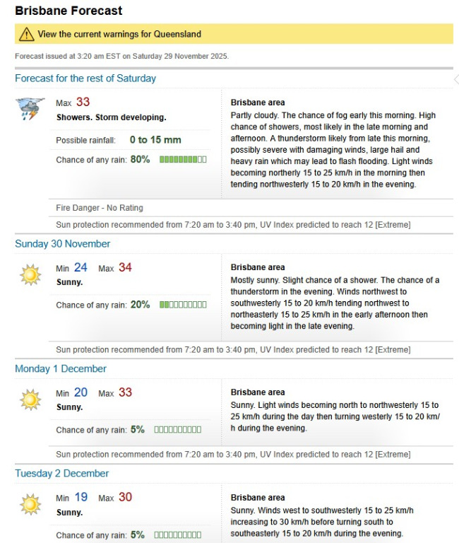 Today is another one of those days to keep an eye on the radar and stay up to date with all weather warnings. Stay safe everyone.
|
1 user thanked Aussie Girl for this useful post.
|
|
|
|
Rank: Advanced Member
Groups: Registered
Joined: 13/03/2024(UTC) Posts: 161 Location: South East Qld Thanks: 457 times
Was thanked: 152 time(s) in 149 post(s)
|
And so it begins... 
|
1 user thanked Aussie Girl for this useful post.
|
|
|
|
Rank: Advanced Member
Groups: Registered
Joined: 13/03/2024(UTC) Posts: 161 Location: South East Qld Thanks: 457 times
Was thanked: 152 time(s) in 149 post(s)
|
Some small cells starting to pop up on the radar around the Darling Downs and Granite Belt areas, as well as Northern NSW. Radar image from 4.50pm this afternoon: 
|
2 users thanked Aussie Girl for this useful post.
|
|
|
|
Rank: Advanced Member
Groups: Registered
Joined: 13/03/2024(UTC) Posts: 161 Location: South East Qld Thanks: 457 times
Was thanked: 152 time(s) in 149 post(s)
|
Storms have built up and become quite widespread now. A Severe Thunderstorm Warning has been issued for some of the storms:  The latest radar image from 7.45pm: 
|
1 user thanked Aussie Girl for this useful post.
|
|
|
|
Rank: Advanced Member
Groups: Registered
Joined: 13/03/2024(UTC) Posts: 161 Location: South East Qld Thanks: 457 times
Was thanked: 152 time(s) in 149 post(s)
|
Not much around in the way of storms so far this evening. There was a storm warning issued at 6.36 for the storm near Nanango and Blackbutt areas: 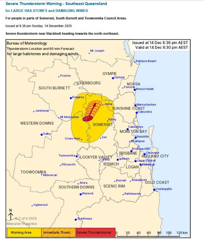 And that storm on the radar image at 7.15pm: 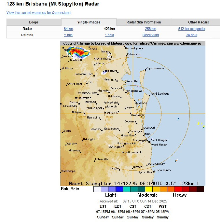 And a view of the storm clouds in the distance. Unfortunately I kept missing the lightning in the clouds when I was taking the photos. 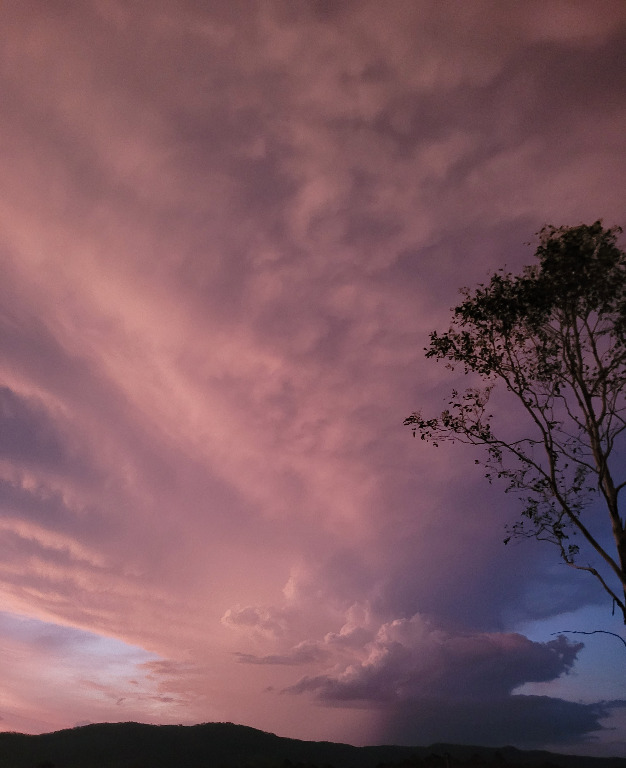
|
1 user thanked Aussie Girl for this useful post.
|
|
|
|
Rank: Advanced Member
Groups: Registered
Joined: 13/03/2024(UTC) Posts: 161 Location: South East Qld Thanks: 457 times
Was thanked: 152 time(s) in 149 post(s)
|
After those last few very warm days and sweltering nights it looks like there is some rain and possible storms on the way for the South East starting today. A mixed bag of maximum temperatures is forecast for the next few days varying between a cooler 26°C for Friday and a warm 34°C for today. The BOM forecast for the Brisbane area:  This is what the radar looked like at 7.05am this morning: 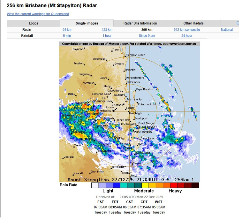 A Severe Thunderstorm Warning was issued at 6.49am this morning for the Toowoomba and Western Downs areas: 
|
1 user thanked Aussie Girl for this useful post.
|
|
|
|
Rank: Advanced Member
Groups: Registered
Joined: 13/03/2024(UTC) Posts: 161 Location: South East Qld Thanks: 457 times
Was thanked: 152 time(s) in 149 post(s)
|
A Storm Warning has been issued at 5.01pm for the Gympie, Noosa and Sunshine Coast regions:  The 256km radar image from 5.05pm. Some good rain in these storms. 
|
1 user thanked Aussie Girl for this useful post.
|
|
|
|
Rank: Advanced Member
Groups: Registered
Joined: 13/03/2024(UTC) Posts: 161 Location: South East Qld Thanks: 457 times
Was thanked: 152 time(s) in 149 post(s)
|
Another stormy afternoon. A Storm Warning has been issued for multiple storms for parts of the South East:  The radar image at 2.30pm this afternoon: 
|
1 user thanked Aussie Girl for this useful post.
|
|
|
|
Rank: Advanced Member
Groups: Registered
Joined: 13/03/2024(UTC) Posts: 161 Location: South East Qld Thanks: 457 times
Was thanked: 152 time(s) in 149 post(s)
|
After those cooler few days we have a warm day to finish off 2025 with a maximum forecast temperature for the Brisbane area of 33°C. There is also the possibility of a thunderstorm in the west in the evening. Here is the Brisbane forecast for the next few days. They will be slightly cooler than today and there is also the possibility of showers over the next few days. 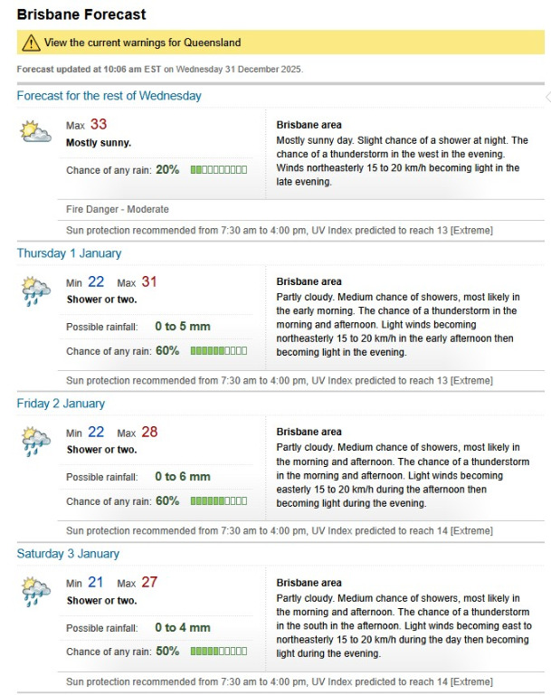 Stay safe and remember to keep hydrated.
|
1 user thanked Aussie Girl for this useful post.
|
|
|
|
Rank: Advanced Member
Groups: Registered
Joined: 13/03/2024(UTC) Posts: 161 Location: South East Qld Thanks: 457 times
Was thanked: 152 time(s) in 149 post(s)
|
The radar is really lighting up with storms at the moment. This is the image from 5.40pm: 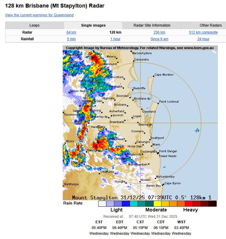 A Severe Thunderstorm Warning has been issued for the Scenic Rim area. 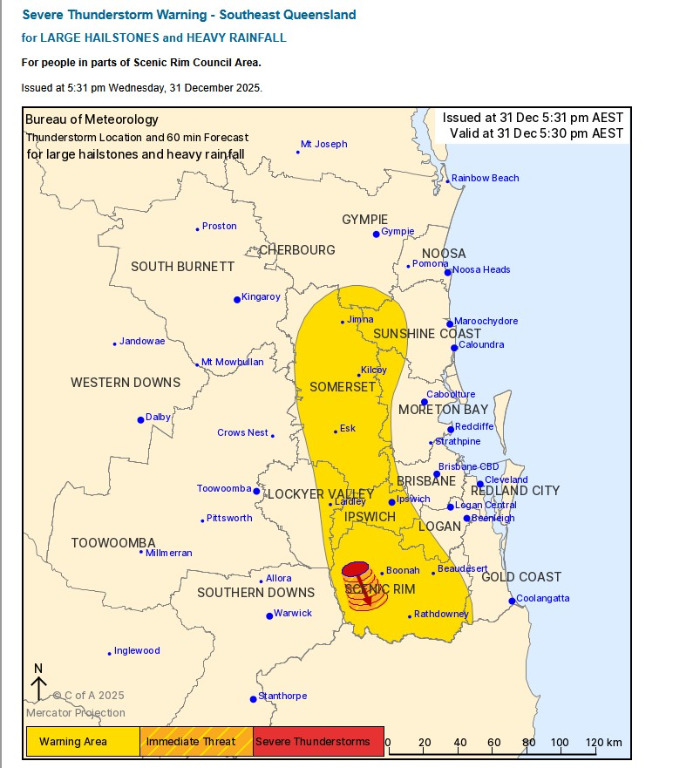
|
|
|
|
|
|
Weather Forum
»
Australia Weather
»
SEQ and NE NSW
»
SE QLD and NE NSW - Day to day Weather 2025
Forum Jump
You cannot post new topics in this forum.
You cannot reply to topics in this forum.
You cannot delete your posts in this forum.
You cannot edit your posts in this forum.
You cannot create polls in this forum.
You cannot vote in polls in this forum.
Important Information:
The Weather Forum uses cookies. By continuing to browse this site, you are agreeing to our use of cookies.
More Details
Close
