Rank: Advanced Member
Groups: Registered
Joined: 26/08/2019(UTC) Posts: 122  Location: Travel but often NSW Thanks: 168 times
Was thanked: 90 time(s) in 53 post(s)
|
An interest l had many moons ago.All things that drive the weather Might get back to There is a long list and l am sure this list is not exhaustive For anyone who may follow this , here are the abbreviations and their meanings Often referred to as natural variability. ENSO.. refers to the El Niño/Southern Oscillation IOD..Indian ocean dipole AAO...Antartic oscillation. or SAM..southern annular mode PDO.....Pacific decadal oscillation SSTs'. Sea surface temperatures AO.. Northern hemisphere.. Arctic oscillation NAM...Northern annular mode PV....Polar vortex MJO..Madden Julian Oscillation BLOCKING index That list is some of the major players 
|
 3 users thanked snowbunny for this useful post.
|
|
|
|
Rank: Advanced Member
Groups: Registered
Joined: 26/08/2019(UTC) Posts: 122  Location: Travel but often NSW Thanks: 168 times
Was thanked: 90 time(s) in 53 post(s)
|
|
 2 users thanked snowbunny for this useful post.
|
|
|
|
Rank: Advanced Member
Groups: Registered
Joined: 23/08/2019(UTC) Posts: 155  Location: Narangba Thanks: 280 times
Was thanked: 442 time(s) in 136 post(s)
|
That is awesome. Thank you for posting and for starting the new topic on it.
Helps with my quest for learning
|
|
|
|
|
|
Rank: Advanced Member
Groups: Registered
Joined: 24/08/2019(UTC) Posts: 292  Location: Country Victorian Thanks: 580 times
Was thanked: 503 time(s) in 194 post(s)
|
31st Aug 2019...Last day of winterA moderate meridonal (wavy)flow of both the polar and sub polar jet. But that isn’t going to help rain enhancement as a stalled weak high pressure area over most of Australia persists this week. 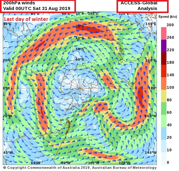 http://www.bom.gov.au/au...chartSubmit=Refresh+View http://www.bom.gov.au/au...chartSubmit=Refresh+View
|
|
|
|
|
|
Rank: Advanced Member
Groups: Registered, Administrators Joined: 21/08/2019(UTC) Posts: 941  Location: Brisbane Northside Thanks: 1198 times
Was thanked: 1136 time(s) in 674 post(s)
|
|
Colin Maitland. |
 6 users thanked Colmait for this useful post.
|
|
|
|
Rank: Advanced Member
Groups: Registered
Joined: 26/08/2019(UTC) Posts: 36  Location: Just south of Cairns Thanks: 68 times
Was thanked: 52 time(s) in 27 post(s)
|
Originally Posted by: Colmait  Haha. What a great website. That made me chuckle. Almost makes me want to go out a buy a dog and call it Monsoon.
|
 2 users thanked NotCrocDundee for this useful post.
|
|
|
|
Rank: Advanced Member
Groups: Registered
Joined: 23/08/2019(UTC) Posts: 155  Location: Narangba Thanks: 280 times
Was thanked: 442 time(s) in 136 post(s)
|
Originally Posted by: Colmait  Thats brilliant. Thank you for sharing.
|
 1 user thanked CantSpellNarangba for this useful post.
|
|
|
|
Rank: Advanced Member
Groups: Registered
Joined: 24/08/2019(UTC) Posts: 292  Location: Country Victorian Thanks: 580 times
Was thanked: 503 time(s) in 194 post(s)
|
Originally Posted by: Colmait  Thanks for that link on the climate kelpies. It was a fabulous initiative. So glad the site and concept is still online. I haven't seen a link to this site from the BOM web site. Maybe l didn't look hard enough? I spent a bit of time looking in their yesterday and found some great stuff. One particular article l posted on my blog. Linking the polar vortex to dry and warm conditions in NE Australia. I thought this article was very pertinent to our current weather pattern this past autumn and winter. A weakened polar vortex brings warm and try to the NE section of OZ.. I am going to look into this research a bit more in the coming days when time permits . My initial thoughts were .Gee another climate kelpie ...called PV? (polar vortex) Actually whilst trying to track the original research article source which is no longer connected. damn. I saw some fabulous research from our own home grown Australia I thought l might start a new thread tomorrow to highlight some of the research work that is being done on our own soil. New understanding of the drivers behind hot and dry conditions over Australia’s north-east
Posted by BCG on 14th March 2019
http://www.climatekelpie...r-australias-north-east/
|
 1 user thanked crikey for this useful post.
|
|
|
|
Rank: Advanced Member
Groups: Registered, Administrators Joined: 21/08/2019(UTC) Posts: 941  Location: Brisbane Northside Thanks: 1198 times
Was thanked: 1136 time(s) in 674 post(s)
|
Both the Artics play a very important role in our climate. One of the main players is the ocean currents both the shallow and then the very deep currents. These all rotate around the Artoc and the Antarctic. The problem faced is salinity disrupted by too much fresh water from melting ice. There is so much to this, it is one of the main drivers that controls our weather right around the world. https://oceanservice.noa...urrents/05conveyor1.htmlhttp://oceanmotion.org/html/impact/conveyor.htmSimplified version of the conveyer belt.   A little more detailed map.  |
Colin Maitland. |
 2 users thanked Colmait for this useful post.
|
|
|
|
Rank: Advanced Member
Groups: Registered
Joined: 23/08/2019(UTC) Posts: 155  Location: Narangba Thanks: 280 times
Was thanked: 442 time(s) in 136 post(s)
|
This is all great everyone. Thank you for posting and it gives me lots of bed time reading!
|
 1 user thanked CantSpellNarangba for this useful post.
|
|
|
|
Rank: Advanced Member
Groups: Registered
Joined: 24/08/2019(UTC) Posts: 292  Location: Country Victorian Thanks: 580 times
Was thanked: 503 time(s) in 194 post(s)
|
Thought l would share this with you. A post from my blog.
Quite significant for me. I wasn't aware of the correlation between PV geopotential height and AAO phase .
and that 10hpa September 2019 anomaly. I wonder how that will translate?
..............................me notes
A very strong anomaly in geopotential height in the upper stratosphere first week of spring. Sept 2019. ??? Have to watch to see how this translates ,(re: teleconnectons) ?
An incredible correlation between vertical geopotential height and the phase of the AAO. Amazing l have never noted that before.,A light bulb moment.
When geopotential height between surface to 100 hPa is positive . The AAO index is negative.
When geopotential height between surface and 100 hPa is negative. The AAO index is positive.
Some convincing proof that the condition of the polar vortex affects our weather.
https://weathercycles.fi...e-to-sept-pv-geoht-1.jpg

|
 4 users thanked crikey for this useful post.
|
|
|
|
Rank: Advanced Member
Groups: Registered
Joined: 24/08/2019(UTC) Posts: 292  Location: Country Victorian Thanks: 580 times
Was thanked: 503 time(s) in 194 post(s)
|
The Polar Vortex at 10hPa is extremely displaced from its sth pole position.It is not centred at all. A strengthening 10hPa anticyclone looks to be causing the displacement.
This picture snapped today 13th sept 2019.Thanks to nullschool windstreams
There are some serious warming anomalies at the 10hPa layer. Now for the what happens next?
The 200mhPa jetstream Sub polar jet continues to be weak. Contracted well south despite a neg AAO this winter and the high velocity streaks , very few..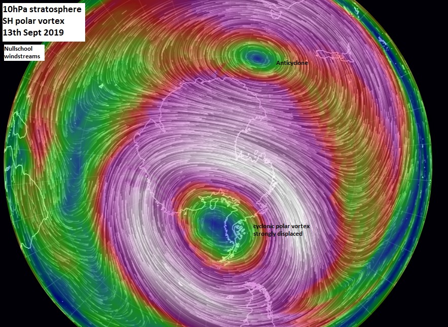 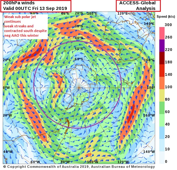
|
 3 users thanked crikey for this useful post.
|
|
|
|
Rank: Advanced Member
Groups: Registered
Joined: 24/08/2019(UTC) Posts: 292  Location: Country Victorian Thanks: 580 times
Was thanked: 503 time(s) in 194 post(s)
|
I had a look at the SH synoptic today because l wondered why we have had so much High pressure this past couple of weeks.
I usually pay attention..
The synoptic shows there is plenty of cut offs and even a big long wave trough.
I wondered if Australia was in a region of blocking or maybe standing wave. Either way this picture suggests we have been short changed source http://www.bom.gov.au/au...chartSubmit=Refresh+View
|
 3 users thanked crikey for this useful post.
|
|
|
|
Rank: Advanced Member
Groups: Registered
Joined: 28/08/2019(UTC) Posts: 33  Location: southaustralia Thanks: 43 times
Was thanked: 28 time(s) in 18 post(s)
|
|
 2 users thanked southawk for this useful post.
|
|
|
|
Rank: Advanced Member
Groups: Registered
Joined: 24/08/2019(UTC) Posts: 292  Location: Country Victorian Thanks: 580 times
Was thanked: 503 time(s) in 194 post(s)
|
Originally Posted by: southawk  Re: the article.
I will say l was surprised they said the warming started in August 2019.
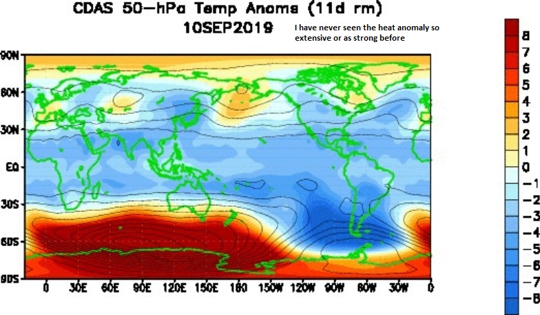
My own research notes and some other amateurs that have been following show significant disturbance to the polar vortex and stratosphere warm anomalies right back in May 2019 .
The current warming anomaly and the sheer extent is the strongest it has been so far (first week of spring). So many eyes will be watching.
 Edited by user Saturday, 14 September 2019 11:36:38 AM(UTC)
| Reason: Not specified
|
 2 users thanked crikey for this useful post.
|
|
|
|
Rank: Advanced Member
Groups: Registered
Joined: 24/08/2019(UTC) Posts: 292  Location: Country Victorian Thanks: 580 times
Was thanked: 503 time(s) in 194 post(s)
|
A positive IOD is known to be correlated with a reduction in Australian rainfall
However l have noted over the years that there are 2 parameters that can overcome the lower rainfall
One. A meridonal jetstream pattern both polar and sub polar can direct moisture down to mid latitudes regardless of the IOD phase.
Two.. A tropical dip in isobars which can draw moist N easterlies in from the coral and the sub tropical trough gives the convection.
There is an example of this in ACC g this week
T+ 150hrs forecast25th September 2019 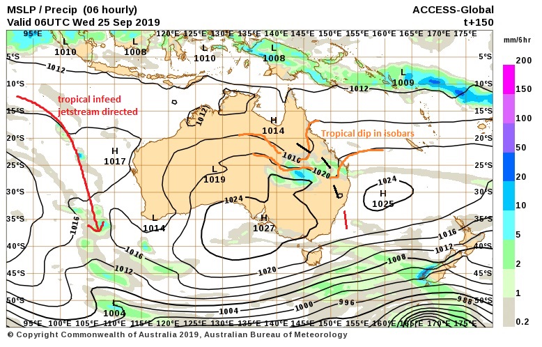
|
 1 user thanked crikey for this useful post.
|
|
|
|
Rank: Advanced Member
Groups: Registered
Joined: 26/08/2019(UTC) Posts: 122  Location: Travel but often NSW Thanks: 168 times
Was thanked: 90 time(s) in 53 post(s)
|
El Nino neutral and a whopping sustained negative SOI ( usually an El Nino indicator)
https://www.longpaddock.qld.gov.au/soi/
What does this mean for our Australian weather for spring/summer?
Negative SOI means anomalous high pressure over Darwin??? Is that correct?
|
 1 user thanked snowbunny for this useful post.
|
|
|
|
Rank: Advanced Member
Groups: Registered
Joined: 24/08/2019(UTC) Posts: 292  Location: Country Victorian Thanks: 580 times
Was thanked: 503 time(s) in 194 post(s)
|
|
 1 user thanked crikey for this useful post.
|
|
|
|
Forum Jump
You cannot post new topics in this forum.
You cannot reply to topics in this forum.
You cannot delete your posts in this forum.
You cannot edit your posts in this forum.
You cannot create polls in this forum.
You cannot vote in polls in this forum.
Important Information:
The Weather Forum uses cookies. By continuing to browse this site, you are agreeing to our use of cookies.
More Details
Close

