Weather Forum

Welcome Guest! To enable all features please Login or Register.

Notification

Icon
Error

4 Pages123>»
Share
Options
Go to last post Go to first unread
Offline CantSpellNarangba  
#1 Posted : Sunday, 15 September 2019 10:43:14 AM(UTC)
CantSpellNarangba

Rank: Advanced Member

Groups: Registered
Joined: 23/08/2019(UTC)
Posts: 155
Australia
Location: Narangba

Thanks: 280 times
Was thanked: 442 time(s) in 136 post(s)
First new topic for me! If I can work out how to do it.

For the last few days GFS has been hinting a small inland low would form bring North / North East winds to this area, pushing rain and instability north along the coast and possibly up into South East Queensland.

A few other models are starting to join in with this theory and as Ken expertly said in the day to day thread "Tuesday does have a few aspects supportive of severe thunderstorm/supercell potential for southern parts of SE QLD/NE NSW - strong shear and nice wind profile, not much cloud cover, and a coastal change". Right now I am hoping Ken would pop in and put me out of my misery of trying to interpret weather charts. Haha BigGrin Ken... Help me!

Here are a few charts off of PabloAkos website, which I have been chatting to him about how he creates them, so they are really the only ones I have been playing with so far. If anyone has any other suggestions, let me know.

Low level humidity is very low in SEQ, but better in NSW (May be because by this date/time it has already rained... Hmm, perhaps I may be wrong now. Confused )
Humidity.png

Surface winds are from the N / NW (As Ken said)
Surface65.png

Steering winds are from the west and pumping!
500hpa65.png

CAPE (I learnt what that was today) - Not too great. Better down south and wonderful off shore.
Cape.png

LI (I learnt about today too!) - Better down south and off shore again
LI.png


The rest, I am still trying to lean and work out, so please feel free to help me! Dancing
I hope Ken or Crikey puts me out of my misery and tells me I am correct so far. Haha! Anyway, I hope the next few days are better than endless smoke filled sky.

Edited by moderator Wednesday, 18 September 2019 5:20:24 AM(UTC)  | Reason: Not specified

thanks 9 users thanked CantSpellNarangba for this useful post.
DelBoy on 15/09/2019(UTC), Paul Atkins on 15/09/2019(UTC), SunSpots on 15/09/2019(UTC), crikey on 15/09/2019(UTC), SatMan on 15/09/2019(UTC), Colmait on 15/09/2019(UTC), Falling_Droplet on 15/09/2019(UTC), sharjay on 16/09/2019(UTC), Pabloako on 18/09/2019(UTC)
Offline DelBoy  
#2 Posted : Sunday, 15 September 2019 10:45:02 AM(UTC)
DelBoy

Rank: Advanced Member

Groups: Registered
Joined: 13/09/2019(UTC)
Posts: 118
Location: Caboolture (the next Las Vegas!)

Thanks: 215 times
Was thanked: 297 time(s) in 100 post(s)
Well... First of CSN... As we say in Australia "Well done for giving it a bloody good go!" and for creating the new thread.
Personally, I can'help you, however BOM WATL is slowly edging its rain totals northwards over the last couple of runs, so they are slowly getting into the swing of this event too. More NSW and then scoots off Northwards.


PME24_aus.png


Hopefully someone with more than my 11 brain cells can explain more.

Edited by user Sunday, 15 September 2019 10:47:18 AM(UTC)  | Reason: Not specified

thanks 5 users thanked DelBoy for this useful post.
crikey on 15/09/2019(UTC), SatMan on 15/09/2019(UTC), Colmait on 15/09/2019(UTC), Falling_Droplet on 15/09/2019(UTC), sharjay on 16/09/2019(UTC)
Offline SunSpots  
#3 Posted : Sunday, 15 September 2019 1:11:51 PM(UTC)
SunSpots

Rank: Member

Groups: Registered
Joined: 10/09/2019(UTC)
Posts: 13
Location: Melbourne (Where it rains)

Thanks: 34 times
Was thanked: 17 time(s) in 9 post(s)
Great job CantSpell (I can't spell Naran... whatever too!) and thank you for starting the tread.
As a part time Rural Fire person down here in chilly Melbourne, I am eagerly waiting to see if some of the areas impacted in NSW get some well needed wet stuff.
thanks 3 users thanked SunSpots for this useful post.
crikey on 15/09/2019(UTC), Colmait on 15/09/2019(UTC), Falling_Droplet on 15/09/2019(UTC)
Offline crikey  
#4 Posted : Sunday, 15 September 2019 3:23:38 PM(UTC)
crikey

Rank: Advanced Member

Groups: Registered
Joined: 24/08/2019(UTC)
Posts: 292
Australia
Location: Country Victorian

Thanks: 580 times
Was thanked: 503 time(s) in 194 post(s)
Thanks CPN for starting the first thread for this forum. BigGrin

There hasn't been a lot on the cards lately , so this is a nice change.


ACCESS G has done a downgrade of this troughing.

It no longer suggests a low circulation forming on the coast and that puts a lid on the bigger potential.

ACC giving most to NE NSW coast and the lighter signal northward up the coast to the mid coast of QLD.


Hopefully a tad of that wet stuff will reach a few of the fires west of the divide.

It will be interesting to see what the others models sug
gest.

trough NE NSW 17th sept 2019
thanks 5 users thanked crikey for this useful post.
CantSpellNarangba on 15/09/2019(UTC), SatMan on 15/09/2019(UTC), Colmait on 15/09/2019(UTC), Falling_Droplet on 15/09/2019(UTC), sharjay on 16/09/2019(UTC)
Offline Ken  
#5 Posted : Sunday, 15 September 2019 3:52:21 PM(UTC)
Ken

Rank: Advanced Member

Groups: Registered
Joined: 2/09/2019(UTC)
Posts: 105
Australia
Location: Brisbane

Thanks: 145 times
Was thanked: 561 time(s) in 103 post(s)
UserPostedImage

UserPostedImage

UserPostedImage


Nice work CSN, and thanks for starting up the thread BigGrin

Yeah going by EC, a NW-SE oriented surface trough and front moves up over NSW, deepens over inland northern NSW and possibly forms a small weak low or two there as an upper trough approaches from the west and amplifies. The area of low pressure then intensifies as an east coast low once it reaches waters along the northern-central NSW coast while the upper trough also amplifies further and cuts off a mid/upper low.
But since our region looks like being on the northern end of this setup, it still doesn't look like we'll get too much in the way of any widespread rainfall amounts. More like a bit of short-lived shower and thunderstorm activity later on Tuesday before a drier SW flow wrapping up and around the ECL comes over us and quickly clears it away. But once the ECL gradually weakens offshore, it looks like it might allow a reasonably moist onshore NE flow to become re-established over our region (although not manifesting itself with that much rainfall except for a bit of coastal shower activity).

Basically, the further south you go along the NSW coast, the better the rainfall amounts (parts of the coast on the southern flank of that low may even get moderate to locally heavy falls developing).

1st graphic above - accumulating rainfall scenarios from a range of models for Brisbane out to 10 days.

2nd graphic - accumulated/composite lightning flash density from EC for Tuesday (in case you're not aware already, it's from Windy.com and you can view all sorts of stuff on there).

3rd graphic - the percentage of scenarios from a combo of the past 6 runs of GFS and the US Navy ensemble that are currently forecasting more than 25mm of total rainfall within the next 5 days (up to the end of Thursday).
thanks 8 users thanked Ken for this useful post.
oceangyre on 15/09/2019(UTC), CantSpellNarangba on 15/09/2019(UTC), SatMan on 15/09/2019(UTC), Greg on 15/09/2019(UTC), Colmait on 15/09/2019(UTC), Falling_Droplet on 15/09/2019(UTC), sharjay on 16/09/2019(UTC), crikey on 17/09/2019(UTC)
Offline CantSpellNarangba  
#6 Posted : Sunday, 15 September 2019 5:08:38 PM(UTC)
CantSpellNarangba

Rank: Advanced Member

Groups: Registered
Joined: 23/08/2019(UTC)
Posts: 155
Australia
Location: Narangba

Thanks: 280 times
Was thanked: 442 time(s) in 136 post(s)
That's brilliant Crikey and Ken. I was half along the right lines! Back to the book for me though to pick up another few tips!

Hopefully NSW and Gold Coast get some well missed rain to put the fires out. We have been lucky here fire wise, so I would be happy with some flashes and bangs and a few spots of rain. After this long, it is going to smell wonderful after a bit of rain.

thanks 4 users thanked CantSpellNarangba for this useful post.
Ken on 15/09/2019(UTC), Colmait on 15/09/2019(UTC), Falling_Droplet on 15/09/2019(UTC), crikey on 17/09/2019(UTC)
Offline Colmait  
#7 Posted : Sunday, 15 September 2019 5:57:52 PM(UTC)
Colmait

Rank: Advanced Member

Groups: Registered
Joined: 21/08/2019(UTC)
Posts: 638
Australia
Location: Brisbane Northside

Thanks: 1089 times
Was thanked: 834 time(s) in 389 post(s)
Yeah kudos Can’tSpellNarrannggbahha.
Start again
Kudos CSN.

I have had my eye on everything to work out that one big question. Why all the ants??????
We have been under siege from these small ants and every time they have come out we have had some varying amounts of precipitation over the years. Due to the outlooks and lack of moisture in the atmosphere I know it can’t be massive rainfalls but something has been building.

Stormcast kept showing a very small possibility for the SEQ on Wednesday for about 5 days now, then it backed off and has now corrected itself saying a very small possibility for Tuesday from 13:00 onwards.

As for the ants, well they must feel some sort of atmospheric change coming no matter what it is, even if it doesn’t there must be something to disturb them into action. Also the birds have been getting agitated around 03:00 in the morning just recently.

I am not a hippy, but I believe animals have an instinct plus I look at what the ocean, cloud, wind are doing etc.
Interesting that before the 2003 horrific Tsunami the animals all were trying to head for the hills. The elephants were pulling on their chains, some even breaking loose. A very interesting read. Then I look at the models and try and piece it together.

So what is it?

At this stage I agree with what Ken and others have stated. I don’t think we are going to see tremendous amounts of rain but we could get a maybe small storm or 2 whether that is embedded in some showers or possible cells or just some showers mainly close to the coast.

Northern NSW seems to once again have it over us.

A few charts from storm cast.

206EB1BF-4DFE-4677-8ACF-1C7D0D6AE9E8.pngF6AB28BF-0B13-488C-A985-74AC2FE6390C.png

The forecast sounding is not that spectacular for Brisbane
70E2DF1E-4B3C-4915-A787-DFD2FA5380CE.png

As we draw closer we should see what will unfold.
Colin Maitland.
thanks 7 users thanked Colmait for this useful post.
SatMan on 15/09/2019(UTC), DelBoy on 15/09/2019(UTC), CantSpellNarangba on 15/09/2019(UTC), Ken on 15/09/2019(UTC), Falling_Droplet on 15/09/2019(UTC), sharjay on 16/09/2019(UTC), crikey on 17/09/2019(UTC)
Offline DelBoy  
#8 Posted : Sunday, 15 September 2019 6:49:30 PM(UTC)
DelBoy

Rank: Advanced Member

Groups: Registered
Joined: 13/09/2019(UTC)
Posts: 118
Location: Caboolture (the next Las Vegas!)

Thanks: 215 times
Was thanked: 297 time(s) in 100 post(s)
So good to see the BSCH charts appear on this forum. It makes it feel like home! I will be happy with a few spots and some thunder action this far north. (Caboolture)

Talking of spelling place names like Narangba, I used to have a job in Woolloongabba and used to phone up Dell IT support in Malaysia. Spelling Woolloongabba to a Malaysian person is not an easy feat!

thanks 5 users thanked DelBoy for this useful post.
CantSpellNarangba on 15/09/2019(UTC), Ken on 15/09/2019(UTC), Colmait on 15/09/2019(UTC), Falling_Droplet on 15/09/2019(UTC), crikey on 17/09/2019(UTC)
Offline crikey  
#9 Posted : Monday, 16 September 2019 8:38:08 AM(UTC)
crikey

Rank: Advanced Member

Groups: Registered
Joined: 24/08/2019(UTC)
Posts: 292
Australia
Location: Country Victorian

Thanks: 580 times
Was thanked: 503 time(s) in 194 post(s)
The event a bit closer now.

e first signs of rain in NE NSW and SE QLD , tomorrow on tuesday 17th around 4pm


17th sept trough ne nsw
thanks 3 users thanked crikey for this useful post.
Falling_Droplet on 16/09/2019(UTC), sharjay on 16/09/2019(UTC), Colmait on 16/09/2019(UTC)
Offline SatMan  
#10 Posted : Monday, 16 September 2019 2:45:48 PM(UTC)
SatMan

Rank: Advanced Member

Groups: Registered
Joined: 7/09/2019(UTC)
Posts: 67
Australia
Location: Brisbane

Thanks: 113 times
Was thanked: 207 time(s) in 61 post(s)
The GFS charts I looked at this morning are pushing this more to the south and it just peeps over the border late afternoon and that is it.
Hope it/I am wrong.
thanks 5 users thanked SatMan for this useful post.
crikey on 16/09/2019(UTC), Falling_Droplet on 16/09/2019(UTC), CantSpellNarangba on 16/09/2019(UTC), DelBoy on 16/09/2019(UTC), Colmait on 16/09/2019(UTC)
Offline crikey  
#11 Posted : Monday, 16 September 2019 5:34:07 PM(UTC)
crikey

Rank: Advanced Member

Groups: Registered
Joined: 24/08/2019(UTC)
Posts: 292
Australia
Location: Country Victorian

Thanks: 580 times
Was thanked: 503 time(s) in 194 post(s)
Originally Posted by: SatMan Go to Quoted Post
The GFS charts I looked at this morning are pushing this more to the south and it just peeps over the border late afternoon and that is it.
Hope it/I am wrong.


Watch this current band This is it. . The trough line . currently in NE VIC is due in Our area tomorrow morning around 10am.


The rain band is forecast to track to the NE toward NE NSW . We should see it on radar west of the divide tomorrow morning and more so in the afternoon.

Here is current sat pic' tea time. and below that, todays synoptic showing position of trough and underneath, the four day synoptic showing tomorrow position of trough line.

16th sept Trough contracting to the NE.jpg

16th sept 2019 synoptic

17thn_18th sept synoptic


thanks 4 users thanked crikey for this useful post.
Falling_Droplet on 16/09/2019(UTC), CantSpellNarangba on 16/09/2019(UTC), DelBoy on 16/09/2019(UTC), Colmait on 16/09/2019(UTC)
Offline CantSpellNarangba  
#12 Posted : Monday, 16 September 2019 6:04:44 PM(UTC)
CantSpellNarangba

Rank: Advanced Member

Groups: Registered
Joined: 23/08/2019(UTC)
Posts: 155
Australia
Location: Narangba

Thanks: 280 times
Was thanked: 442 time(s) in 136 post(s)
Great stuff Crikey.
thanks 4 users thanked CantSpellNarangba for this useful post.
crikey on 16/09/2019(UTC), DelBoy on 16/09/2019(UTC), Colmait on 16/09/2019(UTC), Falling_Droplet on 16/09/2019(UTC)
Offline DelBoy  
#13 Posted : Monday, 16 September 2019 6:42:13 PM(UTC)
DelBoy

Rank: Advanced Member

Groups: Registered
Joined: 13/09/2019(UTC)
Posts: 118
Location: Caboolture (the next Las Vegas!)

Thanks: 215 times
Was thanked: 297 time(s) in 100 post(s)
BOM now have "Chance of a gusty storm in the afternoon" for Brisbane on their forecast this evening. Just 40% of rain though.

(Not that I really understand the BOM % chance of rainfall and then a total).

Edited by user Monday, 16 September 2019 6:45:46 PM(UTC)  | Reason: Not specified

thanks 3 users thanked DelBoy for this useful post.
crikey on 16/09/2019(UTC), Colmait on 16/09/2019(UTC), Falling_Droplet on 16/09/2019(UTC)
Offline crikey  
#14 Posted : Monday, 16 September 2019 7:07:31 PM(UTC)
crikey

Rank: Advanced Member

Groups: Registered
Joined: 24/08/2019(UTC)
Posts: 292
Australia
Location: Country Victorian

Thanks: 580 times
Was thanked: 503 time(s) in 194 post(s)
Yes.,Thanks for that info' delboy'',I never thought to check the BOM forecast for storms in our region. NE NSW

I hate storms personally.,So here is notification that l will need to hide under the dooma tomorrow afternoon. Blushing

I will let the forum know of any activity in the Tweed tomorrow

I ....might.... even try to take a photo..Laugh

Northern Rivers
Location Min. Max. Summary
Byron Bay 16 °C 22 °C Possible afternoon storm.
Lismore 10 °C 26 °C Possible afternoon storm.
Yamba 14 °C 23 °C Possible afternoon storm.
Grafton 9 °C 26 °C Possible afternoon storm.
Evans Head 15 °C 24 °C Possible afternoon storm.
Ballina. 11 °C 24 °C Possible afternoon storm.
Murwillumbah 11 °C 28 °C Possible afternoon storm.
Tweed Heads 14 °C 24 °C Possible afternoon storm.

source
http://www.bom.gov.au/nsw/forecasts/towns.shtml

Edited by user Monday, 16 September 2019 7:09:15 PM(UTC)  | Reason: Not specified

Offline Greg  
#15 Posted : Monday, 16 September 2019 7:36:09 PM(UTC)
Greg

Rank: Advanced Member

Groups: Registered
Joined: 26/08/2019(UTC)
Posts: 32
Australia
Location: Bardon

Thanks: 96 times
Was thanked: 138 time(s) in 32 post(s)
Originally Posted by: DelBoy Go to Quoted Post
BOM now have "Chance of a gusty storm in the afternoon" for Brisbane on their forecast this evening. Just 40% of rain though.

(Not that I really understand the BOM % chance of rainfall and then a total).


Hi Delboy,

First post here and hopefully an image as well - also a WZ orphanBigGrin

I found this image on the ABC website awhile ago explaining BOM rainfall forecasts. I've always referred to it as it is fairly simple. Hope this helps.

Cheers Greg

image-explaining-how-to-read-a-weather-forecast-data.jpg
thanks 8 users thanked Greg for this useful post.
Paul Atkins on 16/09/2019(UTC), CantSpellNarangba on 16/09/2019(UTC), NotCrocDundee on 16/09/2019(UTC), DelBoy on 16/09/2019(UTC), Colmait on 16/09/2019(UTC), NoDrops on 16/09/2019(UTC), Falling_Droplet on 16/09/2019(UTC), crikey on 17/09/2019(UTC)
Offline CantSpellNarangba  
#16 Posted : Monday, 16 September 2019 7:43:56 PM(UTC)
CantSpellNarangba

Rank: Advanced Member

Groups: Registered
Joined: 23/08/2019(UTC)
Posts: 155
Australia
Location: Narangba

Thanks: 280 times
Was thanked: 442 time(s) in 136 post(s)
Welcome Greg and thank you for posting the image. I remember seeing something like that a while ago and could never find it.
thanks 3 users thanked CantSpellNarangba for this useful post.
Colmait on 16/09/2019(UTC), Falling_Droplet on 16/09/2019(UTC), crikey on 17/09/2019(UTC)
Offline DelBoy  
#17 Posted : Monday, 16 September 2019 7:47:22 PM(UTC)
DelBoy

Rank: Advanced Member

Groups: Registered
Joined: 13/09/2019(UTC)
Posts: 118
Location: Caboolture (the next Las Vegas!)

Thanks: 215 times
Was thanked: 297 time(s) in 100 post(s)
That brilliant Greg. Thank you for posting and welcome to our growing clan of weather watchers!
thanks 3 users thanked DelBoy for this useful post.
Colmait on 16/09/2019(UTC), Falling_Droplet on 16/09/2019(UTC), crikey on 17/09/2019(UTC)
Offline Colmait  
#18 Posted : Monday, 16 September 2019 7:48:40 PM(UTC)
Colmait

Rank: Advanced Member

Groups: Registered
Joined: 21/08/2019(UTC)
Posts: 638
Australia
Location: Brisbane Northside

Thanks: 1089 times
Was thanked: 834 time(s) in 389 post(s)
Originally Posted by: DelBoy Go to Quoted Post
BOM now have "Chance of a gusty storm in the afternoon" for Brisbane on their forecast this evening. Just 40% of rain though.

(Not that I really understand the BOM % chance of rainfall and then a total).


Once you get the hang of it, it is easy. To me there is 3 equations. First the percentage.

So if it says 40% chance of rain then what it means (1st equation) there is a 40 % chance of receiving 0.2 mm
of rain or more. 0.2 mm is the lowest BoM record.

Then the forecast may say 5 to 10 mms ( equations 2 &3)

Equation 2. 5mm. BoM are saying there is a 50% chance of receiving 5mm.
Equation 3. 10mm. Bom are stating that there is a 25% chance of receiving tham 10 mm of rain or even more.

So for tomorrow

.D0443FBE-6F2E-4DDE-A612-68DBC2FE8EE0.jpeg

That tell us there is a chance of a thunderstorm but if it eventuates it will be a dry storm or very little rain. Therefore with the wind there is a great risk of lightning causing bushfires.

For a full read of how to understand the forecast it is here.

http://www.bom.gov.au/NexGenFWS/rainfall-faq.shtml
Colin Maitland.
thanks 5 users thanked Colmait for this useful post.
i4hanish on 16/09/2019(UTC), CantSpellNarangba on 16/09/2019(UTC), NoDrops on 16/09/2019(UTC), Falling_Droplet on 16/09/2019(UTC), crikey on 17/09/2019(UTC)
Offline Ken  
#19 Posted : Monday, 16 September 2019 8:06:41 PM(UTC)
Ken

Rank: Advanced Member

Groups: Registered
Joined: 2/09/2019(UTC)
Posts: 105
Australia
Location: Brisbane

Thanks: 145 times
Was thanked: 561 time(s) in 103 post(s)
UserPostedImage

UserPostedImage

I posted a similar rundown elsewhere today but here's my thoughts on Tuesday's setup for the low-rainfall shower and gusty thunderstorm activity.
We're pretty close to the event now but I'm always a bit cautious since I find the northern end of such setups can often be touch and go, and only a slight downgrade can make a big difference for us.

I'm figuring the majority of locations that do get any activity will probably get less than 10mm (a lucky few may get more) in a short and sharp downpour with big fat raindrops... and of course, there's the dry lightning factor especially given the elevated fire dangers through Tuesday.

I think the most likely scenario will play out in this order:

1. A few inland afternoon showers/storms start firing up over higher ground mainly in the south (near the QLD/NSW border), the northern NSW tablelands, and possibly also in western parts of SEQ/far eastern Downs where the cap is weaker.
2. This activity rapidly moves eastwards on the strong westerly steering winds aloft.
3. The activity may become a bit more numerous as it get closer to the coast and encounters the seabreeze front and more moisture (but more stable air near the coast in the form of a cap makes this less than certain).
4. Later in the afternoon or early evening, this activity may eventually reach some sections of the coast as gusty low-rainfall high-based storms (some may try to develop some low level bases near the coast though) but if the cap is too strong near the coast, there is the risk these storms may die before reaching there.

Also, the chances of showers/storms get lower the further north you go (e.g. the Sunshine Coast has a lower risk but I still wouldn't rule out the possibility of activity reaching there yet).

It's a different story further south along the NSW coast though with rainfall amounts likely to be better there (some parts of the Hunter may even get moderate to locally heavy falls later Tuesday night, aided by the moist winds wrapping around a developing east coast low)..... but the southerly change pushing up the NSW MNC coast in the morning might be something to consider re any thunderstorm potential there.

The change creates a bit of a triple point in southwestern SE QLD as it clashes with the NNE'lies from the seabreeze effect and the drier inland westerlies although the change itself looks like stalling and washing out over southern SE QLD later.

ACCESS-C soundings look significantly drier overall than GFS soundings, at least at first, and both have a fair bit of capping in various areas (weaker around the ranges in the southwest) but 00z ACCESS-C does still try to fire up some low rainfall showers/storms mainly over higher ground in inland southern and western SE QLD and NE NSW before sweeping them in an ESE direction towards the coast very late afternoon/early evening.

Shear is good but moisture and capping takes a bit of an edge off the excitement.

Colder air aloft associated with the midlevel trough passing by to the south may help things a bit in southern parts as well as the right exit region of a jet streak producing upper divergence there.

EC suggests the band of mid and high cloud currently to our distant south may creep up to areas near the QLD/NSW border by the morning with sunnier conditions north of that.

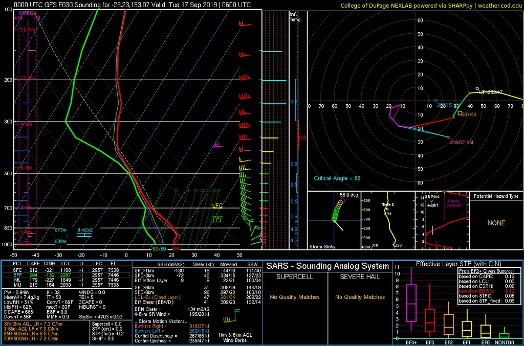
1st image above is a forecast GFS sounding for Darlington (around the border ranges region) for 4pm.

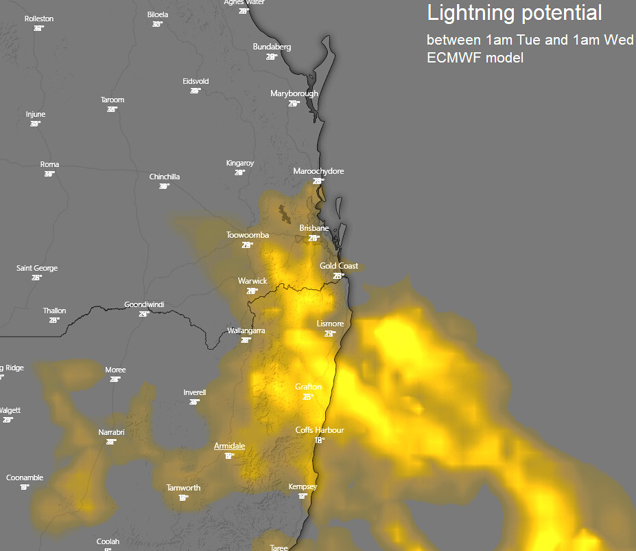
2nd image above is a map via Windy is a composite of multiple images of forecast lightning frequency from EC for the period covering 1am Tue to 1am Wed.

So not much useful rainfall and the prospect of dry gusty storms is a bit worrying... and majority of any afternoon/evening activity favouring inland southern parts... but still a chance elsewhere (northern parts with lower chances although not impossible).
thanks 10 users thanked Ken for this useful post.
Paul Atkins on 16/09/2019(UTC), CantSpellNarangba on 16/09/2019(UTC), DelBoy on 16/09/2019(UTC), Greg on 16/09/2019(UTC), Colmait on 16/09/2019(UTC), NoDrops on 16/09/2019(UTC), Falling_Droplet on 16/09/2019(UTC), sharjay on 17/09/2019(UTC), Xany on 17/09/2019(UTC), crikey on 17/09/2019(UTC)
Offline CantSpellNarangba  
#20 Posted : Monday, 16 September 2019 8:19:08 PM(UTC)
CantSpellNarangba

Rank: Advanced Member

Groups: Registered
Joined: 23/08/2019(UTC)
Posts: 155
Australia
Location: Narangba

Thanks: 280 times
Was thanked: 442 time(s) in 136 post(s)
Wow. Information overload! Yay!
Thanks you Colin, Greg and Ken. A bit of reading and digesting for me.
This is great!
thanks 4 users thanked CantSpellNarangba for this useful post.
Colmait on 16/09/2019(UTC), Falling_Droplet on 16/09/2019(UTC), Ken on 16/09/2019(UTC), crikey on 17/09/2019(UTC)
Users browsing this topic
Guest (4)
4 Pages123>»
Forum Jump  
You cannot post new topics in this forum.
You cannot reply to topics in this forum.
You cannot delete your posts in this forum.
You cannot edit your posts in this forum.
You cannot create polls in this forum.
You cannot vote in polls in this forum.

Weather Forum

Weatherzone Forum Alternative

The Weather Forum for Australia

Australian Weather Forum

Weather Forum for Australia, climate change, storm chasing, cyclones, weather photography