Weather Forum
»
Australia Weather
»
SEQ and NE NSW
»
SE QLD and NE NSW - Day to day Weather 2025
Rank: Advanced Member
Groups: Registered, Administrators Joined: 21/08/2019(UTC) Posts: 941  Location: Brisbane Northside Thanks: 1198 times
Was thanked: 1136 time(s) in 674 post(s)
|
My daughter was out with friends and having dinner at Newstead when hail started to fall. She said it was not big and didn’t last long. She was very fortunate that it was just the edge of the storm that hit them as it headed NE. But a short distance away in New Farm, a restaurant had its roof torn off with the high winds from the same storm.  Here is the 9 news article. https://www.9news.com.au...c-4f80-a0d0-7320027dcb32Edited by user Saturday, 25 January 2025 10:35:37 AM(UTC)
| Reason: Had to add not before big. |
Colin Maitland. |
 1 user thanked Colmait for this useful post.
|
|
|
|
Rank: Advanced Member
Groups: Registered
Joined: 13/03/2024(UTC) Posts: 161 Location: South East Qld Thanks: 457 times
Was thanked: 152 time(s) in 149 post(s)
|
That was very fortunate that your daughter only got the edge of that storm Colmait. It is nice to have slightly cooler temperatures today. The forecast maximum temperature for the Brisbane area today is 31°C. Here is the Brisbane forecast for the next few days showing maximum temperatures in the low 30's.  Happy Australia Day 
|
1 user thanked Aussie Girl for this useful post.
|
|
|
|
Rank: Advanced Member
Groups: Registered, Administrators Joined: 21/08/2019(UTC) Posts: 941 Location: Brisbane Northside Thanks: 1198 times
Was thanked: 1136 time(s) in 674 post(s)
|
Not a great deal happening in this area of the threads at this point. Basically we have hot and humid weather to plough through as best as possible. We had a very heavy down pour this morning but you could feel the heat and humidity build throughout the night before it rolled in. Most of the action is up North. The gang in the thread for that area are doing a fantastic job in keeping a non hyped real approach to what is happening. You can follow them here https://www.weatherforum...24-2025-Wet-Season/page9It is an interesting setup as you watch the monsson drifting South. There are a few lows and possible TC’s embedded in the monsson as per the images from BoM and JTWC. But also there has already been very heavy rain and flooding in many areas in the North of Queesnland. Once again you can follow the action in the above thread.   Edited by user Friday, 31 January 2025 6:41:52 AM(UTC)
| Reason: Not specified |
Colin Maitland. |
1 user thanked Colmait for this useful post.
|
|
|
|
Rank: Advanced Member
Groups: Registered, Administrators Joined: 21/08/2019(UTC) Posts: 941 Location: Brisbane Northside Thanks: 1198 times
Was thanked: 1136 time(s) in 674 post(s)
|
We are still stuck in this hot and humid weather pattern. Some nice beefy showers are rolling through. A surface trough is bringing in showers off the Bay and an upper trough is bringing heavier showers from the North West.  |
Colin Maitland. |
1 user thanked Colmait for this useful post.
|
|
|
|
Rank: Advanced Member
Groups: Registered, Administrators Joined: 21/08/2019(UTC) Posts: 941 Location: Brisbane Northside Thanks: 1198 times
Was thanked: 1136 time(s) in 674 post(s)
|
Had some solid falls today. A nice rain train seen on the radar this afternoon.  |
Colin Maitland. |
1 user thanked Colmait for this useful post.
|
|
|
|
Rank: Advanced Member
Groups: Registered
Joined: 13/03/2024(UTC) Posts: 161 Location: South East Qld Thanks: 457 times
Was thanked: 152 time(s) in 149 post(s)
|
It is certainly hot and sticky today. The feel like temperatures are around 3 to 4°C above actual temperatures this morning. BOM have forecast a maximum temperature of 31°C and the possibility of a thunderstorm this afternoon. To me (in my very amateur opinion) it feels like a storm day. This is the Brisbane forecast for the next few days: 
|
1 user thanked Aussie Girl for this useful post.
|
|
|
|
Rank: Advanced Member
Groups: Registered, Administrators Joined: 21/08/2019(UTC) Posts: 941 Location: Brisbane Northside Thanks: 1198 times
Was thanked: 1136 time(s) in 674 post(s)
|
It was an extremely hot and humid day yesterday and you were right Aussie Girl, it did feel like a storm day. I was stuck on a project and it was really unbearable but it had to be completed. Storms started to build in the early part of the evening and continued over the next few hours. We did receive a severe storm warning text at 12:28 this morning as per the images below. Some good rain totals from the heavy rain. We should have the possibility of storms over the next few days as the atmosphere is primed. A fair amount of Cape or instability around the SEQLD and NE NSW.     |
Colin Maitland. |
1 user thanked Colmait for this useful post.
|
|
|
|
Rank: Advanced Member
Groups: Registered, Administrators Joined: 21/08/2019(UTC) Posts: 941 Location: Brisbane Northside Thanks: 1198 times
Was thanked: 1136 time(s) in 674 post(s)
|
Storms are firing off out West and Southwest. Warnings have been issued for large hailstones, damaging winds and heavy rain.   |
Colin Maitland. |
1 user thanked Colmait for this useful post.
|
|
|
|
Rank: Advanced Member
Groups: Registered, Administrators Joined: 21/08/2019(UTC) Posts: 941 Location: Brisbane Northside Thanks: 1198 times
Was thanked: 1136 time(s) in 674 post(s)
|
Some very heavy rain out towards the Scenic Rim this evening. Latest STW   |
Colin Maitland. |
1 user thanked Colmait for this useful post.
|
|
|
|
Rank: Advanced Member
Groups: Registered
Joined: 13/03/2024(UTC) Posts: 161 Location: South East Qld Thanks: 457 times
Was thanked: 152 time(s) in 149 post(s)
|
Originally Posted by: Colmait  It was an extremely hot and humid day yesterday and you were right Aussie Girl, it did feel like a storm day. I was stuck on a project and it was really unbearable but it had to be completed.
Storms started to build in the early part of the evening and continued over the next few hours. We did receive a severe storm warning text at 12:28 this morning as per the images below. Some good rain totals from the heavy rain.
Glad I wasn't the only one who felt like it was a storm day yesterday. I was actually amazed we didn't get one after that morning heat and humidity. That would have been awful for you Colmait if your project was outdoors with no aircon. It is interesting to look at the rainfall areas from that overnight rain last night. The heavier falls only seemed to go east to a certain point. This is the 128km Mt Stapylton 24hr Rainfall image:  This is a link to the BOM radar loop from 9.30pm last night until 4am this morning. It was fascinating to watch the rain cells almost dancing with each other and eventually joining up. The link is to the Oscilmet Weather site: https://www.oscilmet.com...mp;dateFinish=1739296800Hopefully the link works. Edited by user Wednesday, 12 February 2025 8:22:37 PM(UTC)
| Reason: Missing Word
|
1 user thanked Aussie Girl for this useful post.
|
|
|
|
Rank: Advanced Member
Groups: Registered, Administrators Joined: 21/08/2019(UTC) Posts: 941 Location: Brisbane Northside Thanks: 1198 times
Was thanked: 1136 time(s) in 674 post(s)
|
We just seem to get stuck into these monotonous weather patterns although it has been fractionally cooler in the last 2 days and a couple to follow.
Then we are back to above average minimum and maximum temperatures for the South East of Queensland and NE NSW. There is also a slightly higher than average chance of rainfalls for the same area. These forecast for both rainfalls and temperatures are the long range predictions from now until May.
I used to enjoy April from years back because it was when we noticed a dip in temperatures and noticed a change in the seasons. But it seems to have changed like a lot of weather patterns around the world.
|
Colin Maitland. |
1 user thanked Colmait for this useful post.
|
|
|
|
Rank: Advanced Member
Groups: Registered, Administrators Joined: 21/08/2019(UTC) Posts: 941 Location: Brisbane Northside Thanks: 1198 times
Was thanked: 1136 time(s) in 674 post(s)
|
We are now into Autumn and the long range forecast is for a warmer than average temperatures for the next couple of months. But right now the big question is Cyclone Alfred. I have held back from posting anything until we got a little closer. As per cyclones, models throw all sorts of scenarios and you end up with a spaghetti ensemble that shows the cyclone doing all sorts of things and crossing the coast and in so many areas. In the last day, Alfred is starting to take a make itself felt along the Southeast Coast and the Bureau is now starting to get a little bit more of better picture of TC Alfred with a possibility of it crossing the Coast. Even though it is a few days off, things can still change. But with the latest forecast track, it is worth keeping a serious eye on this system. There is now a fair chance that TC Alfred could now cross the Coast from the Sunshine Coast, Brisbane or the Gold Coast Here is the latest update and track maps.    Even though things can change quickly it would be very wise to be prepared for a possible crossing or for some severe weather. I have tried to keep this post a simple as possible without going into all the technicalities. The important thing is watching a being prepared in case instead of reading a massive technical post. |
Colin Maitland. |
1 user thanked Colmait for this useful post.
|
|
|
|
Rank: Advanced Member
Groups: Registered, Administrators Joined: 21/08/2019(UTC) Posts: 941 Location: Brisbane Northside Thanks: 1198 times
Was thanked: 1136 time(s) in 674 post(s)
|
This is the reason I said in my above post that there is a possibility of it crossing the Sunshine Coast (where BoM have it a little further South), I have included the JTWC track map. Cyclones are very unpredictable and can change quickly. But please just keep a watch out for this TC and be prepared in case it does cause problems as a severe weather system off the Coast or it makes a coastal crossing. Here is the JTWC map.  |
Colin Maitland. |
1 user thanked Colmait for this useful post.
|
|
|
|
Rank: Advanced Member
Groups: Registered, Administrators Joined: 21/08/2019(UTC) Posts: 941 Location: Brisbane Northside Thanks: 1198 times
Was thanked: 1136 time(s) in 674 post(s)
|
|
Colin Maitland. |
1 user thanked Colmait for this useful post.
|
|
|
|
Rank: Advanced Member
Groups: Registered
Joined: 13/03/2024(UTC) Posts: 161 Location: South East Qld Thanks: 457 times
Was thanked: 152 time(s) in 149 post(s)
|
This week looks like we are in for a change from those monotonous weather patterns you mentioned Colmait. We went for a drive up the coast today and stopped at Point Arkwright this morning to look at the swell and the waves. It was incredibly windy and the water was very rough. We then drove down to Mooloolabah where the water is normally quite calm. The waves were certainly being whipped up by Alfred's influence and were much larger and messier than normal. The lifeguards were walking up and down the beach telling people to get off the rocks that the waves were crashing onto. This is a photo of how messy the shoreline looked today:  It will be very interesting over the next couple of days to see where TC Alfred goes. If it is going to cross the coast then hopefully everyone in it's path are listening to the warnings and preparing for it.
|
1 user thanked Aussie Girl for this useful post.
|
|
|
|
Rank: Advanced Member
Groups: Registered, Administrators Joined: 21/08/2019(UTC) Posts: 941 Location: Brisbane Northside Thanks: 1198 times
Was thanked: 1136 time(s) in 674 post(s)
|
Hi Aussie Girl Thanks for the update and photo. It would have been interesting to see the swell. When I was in my late teens and early 20’s, I and a few mates used to chase the swell and surf the monsters. Sometimes there would only be a a dozen out in the break. We didn’t have any jet ski’s or safety gear back in the 80’s. A few times you would line one up and as you saw over the lip this massive drop you would just pull out at the last minute. Then the sets would get even bigger and we would paddle even further out. Then you would have your heart and stomach in your mouth and just go for it. But that swell just looks a bit to messy to surf. Tonight on the weather the term Hybrid system was used for TC Alfred but this can diminish the seriousness of the threat. It was said it could be similar to an ECL. But to keep things simple it is still TC Alfred and will still cause possible damage no matter what it is labelled. There are technicalities brought in by BoM in 1978. Sometimes when you analyse it, there is really no difference at times and I believe this is one of those times. There is still time for the system to change. It is a little bit disorganised currently, but is expected to re intensify to at least a Cat 2 system. Tomorrow will give us a better view of what is happening. Hopefully it may move to the East. But for everyone reading please stay alert and listen to the updates and warnings. Edited by user Sunday, 2 March 2025 9:39:54 PM(UTC)
| Reason: Grammar etc |
Colin Maitland. |
1 user thanked Colmait for this useful post.
|
|
|
|
Rank: Advanced Member
Groups: Registered
Joined: 13/03/2024(UTC) Posts: 161 Location: South East Qld Thanks: 457 times
Was thanked: 152 time(s) in 149 post(s)
|
Surfing those monster waves would have been very scary Colmait. I enjoy watching videos of surfers riding huge waves and actually watching large waves at the ocean but no way would I be game enough to go out in them. Even watching too many videos of big waves gives me scary dreams of being caught in them lol  The BOM issued Cyclone Advice No 1 for TC Alfred at 10.54am this morning:  This is a link to the Get Ready Queensland's Tropical Cyclone Alfred page which has many helpful links to help prepare for the coming weather event: https://www.getready.qld...yclone-alfred-march-2025
|
1 user thanked Aussie Girl for this useful post.
|
|
|
|
Rank: Advanced Member
Groups: Registered
Joined: 13/03/2024(UTC) Posts: 161 Location: South East Qld Thanks: 457 times
Was thanked: 152 time(s) in 149 post(s)
|
From the Brisbane City Council Website re the City Cat and Ferry Service: 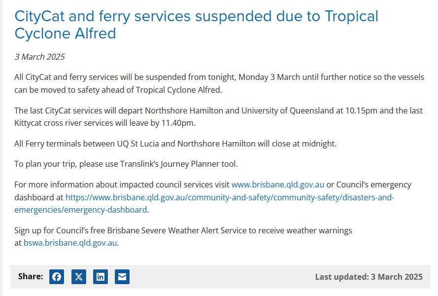
|
1 user thanked Aussie Girl for this useful post.
|
|
|
|
Rank: Advanced Member
Groups: Registered, Administrators Joined: 21/08/2019(UTC) Posts: 941 Location: Brisbane Northside Thanks: 1198 times
Was thanked: 1136 time(s) in 674 post(s)
|
Here is the latest updates for TC Alfred. TROPICAL CYCLONE ADVICE NUMBER 4 Issued at 4:52 am EST on Tuesday 4 March 2025 Headline: Tropical Cyclone Alfred to turn towards the southeast Queensland coast today with a coastal impact later this week. Areas Affected: Warning Zone None. Watch Zone Sandy Cape to Grafton, including Brisbane, Gold Coast, Sunshine Coast, and Byron Bay but not including Grafton. Cancelled Zone None. Details of Tropical Cyclone Alfred 22U at 4:00 am AEST [5:00 am AEDT]: Intensity: Category 2, sustained winds near the centre of 95 kilometres per hour with wind gusts to 130 kilometres per hour. Location: within 30 kilometres of 27.1 degrees South 158.7 degrees East, estimated to be 560 kilometres east of Brisbane and 560 kilometres east of Maroochydore. Movement: south southeast at 6 kilometres per hour. Tropical Cyclone Alfred is currently moving southeast, but it is expected to slow and turn west towards the Queensland coast later today. Alfred's intensity may fluctuate between category 1 and 2 over the next few days, but it is forecast to cross the southeast Queensland coast at category 2 strength late on Thursday or early Friday morning.    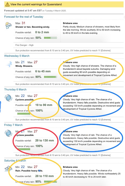   |
Colin Maitland. |
1 user thanked Colmait for this useful post.
|
|
|
|
Rank: Advanced Member
Groups: Registered, Administrators Joined: 21/08/2019(UTC) Posts: 941 Location: Brisbane Northside Thanks: 1198 times
Was thanked: 1136 time(s) in 674 post(s)
|
The latest update with TC. Alfred   |
Colin Maitland. |
1 user thanked Colmait for this useful post.
|
|
|
|
Weather Forum
»
Australia Weather
»
SEQ and NE NSW
»
SE QLD and NE NSW - Day to day Weather 2025
Forum Jump
You cannot post new topics in this forum.
You cannot reply to topics in this forum.
You cannot delete your posts in this forum.
You cannot edit your posts in this forum.
You cannot create polls in this forum.
You cannot vote in polls in this forum.
Important Information:
The Weather Forum uses cookies. By continuing to browse this site, you are agreeing to our use of cookies.
More Details
Close
