Weather Forum
»
Australia Weather
»
SEQ and NE NSW
»
SE QLD and NE NSW - Day to day Weather 2024
Rank: Advanced Member
Groups: Registered
Joined: 13/03/2024(UTC) Posts: 161  Location: South East Qld Thanks: 457 times
Was thanked: 152 time(s) in 149 post(s)
|
According to the latest BOM forecast for the Brisbane area we may see some heavy rainfalls in the coming days, especially on Monday and Tuesday next week. A flood watch warning was issued by BOM this afternoon for some of the South East Qld catchment areas: Initial Flood Watch for the South East Queensland Coastal Catchments
Issued at 2:39 pm EST on Friday 9 August 2024
Flood Watch Number: 1
ISOLATED MINOR FLOODING POSSIBLE ACROSS PARTS OF THE FLOOD WATCH AREA FROM MONDAY
A coastal trough is expected to develop along the northern NSW and Southern QLD coast from Sunday. This trough is likely to deepen along the coast from Monday into Tuesday with heavy rainfall increasing. A low pressure system may develop on the trough on Tuesday.
Catchments within the Flood Watch Area are moderately dry.
Rainfall will increase about northern Queensland later on Sunday and is expected to move south and intensify from Monday into Tuesday. Heavy rainfall is forecast over the Flood Watch Area from Monday until Wednesday morning.
There is a significant uncertainty in the timing and location of the rainfall, although the coast and adjacent ranges are most likely to see the heaviest falls.
Localised river level rises and flash flooding are likely within the areas of heaviest rainfall, with isolated minor to moderate riverine flooding possible.
Due to the localised nature of the heavier falls, at this stage it is not possible to be more specific about the areas of highest flood risk.
Flooding may result in disruption to transport routes and isolation of some communities.
Catchments likely to be affected include:
Mary River
Noosa River
Sunshine Coast Rivers and Creeks
Pine and Caboolture Rivers
Upper Brisbane River
Lower Brisbane River
(Specifically the Bremer River and Lockyer, Laidley and Warrill Creeks)
Logan and Albert Rivers
Gold Coast Rivers and Creeks
See www.bom.gov.au/qld/warnings to view the current flood, weather and cyclone products for Queensland. It will be nice to have some rain again as the ground is really starting to dry out, but it is lousy timing, happening at the same time as the Ekka.
|
 2 users thanked Aussie Girl for this useful post.
|
|
|
|
Rank: Advanced Member
Groups: Registered
Joined: 13/03/2024(UTC) Posts: 161 Location: South East Qld Thanks: 457 times
Was thanked: 152 time(s) in 149 post(s)
|
Starting to get some heavier rain now. This is the BOM 128km Mt Stapylton radar image as at 12.50pm this afternoon.  An updated flood watch has been issued by BOM at 12.20pm this afternoon for Coastal Catchments from Sarina to Tweed Heads: Flood Watch for Coastal Catchments from Sarina to Tweed Heads
Issued at 12:20 pm EST on Monday 12 August 2024
Flood Watch Number: 4
ISOLATED MINOR TO MODERATE FLOODING POSSIBLE ACROSS PARTS OF THE FLOOD WATCH AREA FROM LATE TUESDAY
A rain band extends over eastern and central Queensland. An upper trough extends over Queensland enhancing showers and thunderstorms. The upper trough will move south down the east coast from today, moving offshore late on Wednesday. A surface trough is forecast to develop near the central Queensland coast from today, most likely between Carmila and Hervey Bay, and will enhance rainfall, winds, and seas in its vicinity. The coastal trough will weaken from Thursday.
Catchments within the Flood Watch Area are moderately dry but beginning to wet up after rainfall in coastal areas over the last few days.
Moderate to locally heavy rainfall is possible over the Flood Watch Area from the remainder of Monday until Wednesday, easing on Thursday.
Significant uncertainty still remains in the timing and location of the rainfall, although the coast and adjacent ranges are most likely to see the heaviest falls.
Localised river level rises and flash flooding are likely within the areas of heaviest rainfall, with isolated minor to moderate riverine flooding possible.
Due to the localised nature of the heavier falls, at this stage it is not possible to be more specific about the areas of highest flood risk.
Flooding may result in disruption to transport routes and isolation of some communities.
Catchments likely to be affected include:
Connors, Isaac and Styx Rivers and Plane Creek
Mackenzie and Fitzroy Rivers and Shoalwater and Water Park Creeks
(Riverine flooding not expected in Fitzroy or Mackenzie Rivers at this stage)
Calliope River
Boyne River
Baffle Creek
Kolan River
Burnett River
Burrum and Cherwell Rivers
Mary River
Noosa River
Sunshine Coast Rivers and Creeks
Pine and Caboolture Rivers
Upper Brisbane River
Lower Brisbane River
(including the Bremer River and Lockyer, Laidley and Warrill Creeks, excluding the lower Brisbane River itself)
Logan and Albert Rivers
Gold Coast Rivers and Creeks
See www.bom.gov.au/qld/warnings to view the current flood, weather and cyclone products for Queensland.
|
1 user thanked Aussie Girl for this useful post.
|
|
|
|
Rank: Advanced Member
Groups: Registered
Joined: 13/03/2024(UTC) Posts: 161 Location: South East Qld Thanks: 457 times
Was thanked: 152 time(s) in 149 post(s)
|
Plenty of rain around the south east now. This is the BOM's Mt Stapylton 512km radar image at 3.31pm this afternoon:  BOM has issued a number of current warnings for this rain event, including flood warnings, marine wind warning, hazardous surf warning and a coastal hazard warning.
|
1 user thanked Aussie Girl for this useful post.
|
|
|
|
Rank: Advanced Member
Groups: Registered, Administrators Joined: 21/08/2019(UTC) Posts: 941 Location: Brisbane Northside Thanks: 1198 times
Was thanked: 1136 time(s) in 674 post(s)
|
93 mm here for the event with a few showers still sweeping through. There has been some big falls of over 150mm within the area of this thread. Below is the 24 hour rainfall totals from Mt Stapylton radar for when most of the rain fell. Also a map of the rainfall totals over the SEQLD area. After the rain clears we are in for some leap frog weather with warm to hot days then back to cooler days. Water temperatures have dropped considerably but we are still in a neutral weather pattern. It is still looking like that we will enter into an El Nino phase.  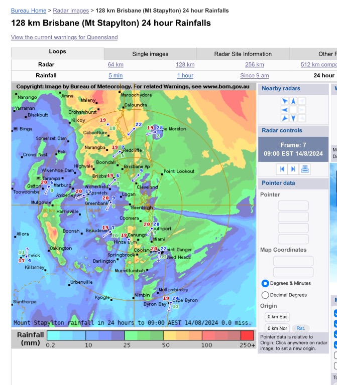 |
Colin Maitland. |
1 user thanked Colmait for this useful post.
|
|
|
|
Rank: Advanced Member
Groups: Registered, Administrators Joined: 21/08/2019(UTC) Posts: 941 Location: Brisbane Northside Thanks: 1198 times
Was thanked: 1136 time(s) in 674 post(s)
|
By the modelling systems it almost appears winter is over and Spring is arriving slightly early. Some warm to hot days ahead and minimums are rising as well.
But this has happened in recent years and it is hard to say for sure that this is the last of the cold weather. Even last year, Spring seemed to arrive early only for the cooler weather to hang around well into October, then unfortunately we were smashed with very hot and humid weather. Our weather patterns have definitely changed. Records are being broken every year.
I will definitely be keeping an eye on this years storm season to see how it will unfold. For the SEQLD there is nothing showing up, but over the border, Lismore could see a storm Wed/Thursday this week.
|
Colin Maitland. |
1 user thanked Colmait for this useful post.
|
|
|
|
Rank: Advanced Member
Groups: Registered
Joined: 13/03/2024(UTC) Posts: 161 Location: South East Qld Thanks: 457 times
Was thanked: 152 time(s) in 149 post(s)
|
It feels like we are skipping Spring and going straight to Summer with the temps this week. And now we have some thunderstorms brewing. This is the 128km Mt Stapylton radar image from 3.25pm. 
|
1 user thanked Aussie Girl for this useful post.
|
|
|
|
Rank: Advanced Member
Groups: Registered, Administrators Joined: 21/08/2019(UTC) Posts: 941 Location: Brisbane Northside Thanks: 1198 times
Was thanked: 1136 time(s) in 674 post(s)
|
Thank you for the update @Aussie Girl. We were down in the Hunter Valley and the winds were extreme as well as very hot and dry. This summer has me on edge. I think at this stage, if things are to continue, this will be a summer of fires again.
One of the Cellar staff had just returned from Perisher after a snowboarding holiday. She said that the snow was so patchy that the were jumping over grass patches. I was watching other snow fields and they had closed the season down. The rain, heat and wind just wiped the snow right out.
Still seems to be a few grass hopper days were temperatures will be very hot and then drop back down to 23 - 24°C then back into the high 20’s and low 30’s before the start of the summer season.
While the East of Australia struggles with high temperatures and damaging winds, over in Southern WA they are predicting snow today. Very crazy. |
Colin Maitland. |
1 user thanked Colmait for this useful post.
|
|
|
|
Rank: Advanced Member
Groups: Registered
Joined: 13/03/2024(UTC) Posts: 161 Location: South East Qld Thanks: 457 times
Was thanked: 152 time(s) in 149 post(s)
|
What a difference a week makes. Here we were last week having hot summer like temperatures in the 30s and this week the temperature has been back down to the low to mid 20's. The evenings have been cool enough to require wearing a jacket. Crazy weather. Originally Posted by: Colmait  Thank you for the update @Aussie Girl. We were down in the Hunter Valley and the winds were extreme as well as very hot and dry. This summer has me on edge. I think at this stage, if things are to continue, this will be a summer of fires again.
One of the Cellar staff had just returned from Perisher after a snowboarding holiday. She said that the snow was so patchy that the were jumping over grass patches. I was watching other snow fields and they had closed the season down. The rain, heat and wind just wiped the snow right out.
The coming summer has me on edge too Colmait. The ABC News had an article on Wednesday titled "Warnings over Increased Bushfire Risk as Australia Records Warmest August on Record" (https://www.abc.net.au/news/2024-09-04/spring-bushfire-outlook-suggests-increased-risk-in-qld-nt-vic-sa/104304072). It feels like we are in uncharted territory with the climate at the moment. Interesting about the Cellar staff telling you about the lack of snow. I was just reading an article this morning that stated that Australia's snow seasons are projected to get shorter as Winters become warmer.
|
1 user thanked Aussie Girl for this useful post.
|
|
|
|
Rank: Advanced Member
Groups: Registered, Administrators Joined: 21/08/2019(UTC) Posts: 941 Location: Brisbane Northside Thanks: 1198 times
Was thanked: 1136 time(s) in 674 post(s)
|
Finally arrived back from the Hunter Valley this afternoon. We got up early so we could hit the road and do the trip in 1 day. My wife and I were sitting on the balcony at farm stay at Mitchells Flats, about 38KM from Muswellbrook. At 05:58 the 4.5 M earthquake at Muswellbrook hit. I have been through a few so it was an interesting way to end the stay. No damage there, just a jolt and shaking. On another note, we were listening to the radio on the way back and we had tuned into the Taree radio station and they were stating that the have not backed burned anywhere near the quota required throughout NSW. A great concern down there. The weather down there was much the same as Brisbane which is very unusual for the area. We had 2 cold nights and one cool day. The rest of the days were min of 13-17°C and 24-31°C for maximums. Below is the GEO science report of the quake this morning .  |
Colin Maitland. |
1 user thanked Colmait for this useful post.
|
|
|
|
Rank: Advanced Member
Groups: Registered
Joined: 13/03/2024(UTC) Posts: 161 Location: South East Qld Thanks: 457 times
Was thanked: 152 time(s) in 149 post(s)
|
That certainly was an interesting way to end your holidays Colmait. The news reported that the earthquake was felt as far away as Western Sydney so I can imagine you would have really felt it quite strongly where you were staying. Thank you for posting the GEO science report of the quake.
That is a bit scary that there has not been enough back burning throughout NSW. The only silver lining is that the fire season for NSW is predicted to be relatively normal this summer. A different story for us in Qld though, including the south east. This is an excerpt from a news article today:
"QFD commissioner Steve Smith said ..... a wet summer this year had given rise to ideal conditions for growth in parts of the state, raising new fire risks.
“We’ve got significant vegetation growth that has cured with a drier-than-average winter,” Mr Smith said.
With some of those frosts curing our fuels, this is elevated fire risk, particularly across northern, central and southern Queensland.”
Of particular concern were southern and central grasslands and forests, particularly around the Scenic Rim area.
Areas to the west in Darling Downs as well as Charleville, up to Warrego and the Maranoa, were also of concern.
“There’s also heightened conditions risk for the Sunshine Coast hinterland,” Mr Smith said.
(https://www.news.com.au/technology/environment/increased-risk-firies-bleak-warning-for-spring-bushfire-season/news-story/3fc14db3ecd930d4ecd1c5fb19f47c49)
|
1 user thanked Aussie Girl for this useful post.
|
|
|
|
Rank: Advanced Member
Groups: Registered, Administrators Joined: 21/08/2019(UTC) Posts: 941 Location: Brisbane Northside Thanks: 1198 times
Was thanked: 1136 time(s) in 674 post(s)
|
Due to the existing high and a new High that will develop in the South of Australia (The Bite), and troughs in Queensland moving around and developing then moving off the Coast, ( so much going on with high and lows  ) our weather for the next week or so, for this area of this thread is going to see cooler daytime temperatures, warmer minimums and a few showers, with maybe a possible rumble or two embedded in some of the showers. I was going to upload the 8 day WATL forecast rainfall totals but it is still trying to finish the end of its model forecast. But it looks like we may see 20-30 mm over the next 7 days on average at this stage, with some areas, under the right band of showers possibly receiving higher totals.. Edited by user Tuesday, 10 September 2024 9:39:48 AM(UTC)
| Reason: Not specified |
Colin Maitland. |
1 user thanked Colmait for this useful post.
|
|
|
|
Rank: Advanced Member
Groups: Registered, Administrators Joined: 21/08/2019(UTC) Posts: 941 Location: Brisbane Northside Thanks: 1198 times
Was thanked: 1136 time(s) in 674 post(s)
|
A fair bit of lightning in the showers passing over SE QLD this afternoon. Below is the Mt Stapylton radar sweep of the showers , the Energex lightning tracker and the Himawari satellite lightning tracker. Pretty cool to come out of the cinema after finally seeing Twisters and seeing darkened skies.    Edited by user Tuesday, 10 September 2024 2:26:21 PM(UTC)
| Reason: Not specified |
Colin Maitland. |
1 user thanked Colmait for this useful post.
|
|
|
|
Rank: Advanced Member
Groups: Registered, Administrators Joined: 21/08/2019(UTC) Posts: 941 Location: Brisbane Northside Thanks: 1198 times
Was thanked: 1136 time(s) in 674 post(s)
|
Our weather is still in a neutral pattern but most likely will eventually swing back into a La Niña cycle once again. But our day to day weather is still in this warm to hot then followed by a cold snap. This will repeat itself once again mid to late Thursday afternoon with a top of 26-28°C possible, then a southern Polar cold blast will hit us making Friday feel like we are back in Winter. The front will also deliver some needed rain with some areas having the possibility of accumulating 40+mm. It is a short blast with temperatures set to soar back up into the 30°C mark by mid next week as the the Cold front moves out to sea around Saturday afternoon. Stay safe and enjoy the wet and cool Friday. Edited by user Wednesday, 25 September 2024 8:08:51 AM(UTC)
| Reason: Spelling. |
Colin Maitland. |
1 user thanked Colmait for this useful post.
|
|
|
|
Rank: Advanced Member
Groups: Registered
Joined: 13/03/2024(UTC) Posts: 161 Location: South East Qld Thanks: 457 times
Was thanked: 152 time(s) in 149 post(s)
|
The last two weeks have been absolutely lovely weather wise. Great outdoor weather for the school holidays. The kids have had lots of fun at the pool and beach. A different story for Friday and Saturday though as Colmait mentioned above. This is the Bom forecast for Brisbane for those days: 
|
1 user thanked Aussie Girl for this useful post.
|
|
|
|
Rank: Advanced Member
Groups: Registered
Joined: 13/03/2024(UTC) Posts: 161 Location: South East Qld Thanks: 457 times
Was thanked: 152 time(s) in 149 post(s)
|
The rain is on its way now to the South East. Here is the BOM 512km Mt Stapylton image at 9.41 pm tonight and from the look of the radar image, some areas will receive a decent amount of rain from this. It will actually be nice to have some rain as the ground is starting to get a bit dry around here.  Edited by user Thursday, 26 September 2024 9:52:16 PM(UTC)
| Reason: Not specified
|
1 user thanked Aussie Girl for this useful post.
|
|
|
|
Rank: Advanced Member
Groups: Registered, Administrators Joined: 21/08/2019(UTC) Posts: 941 Location: Brisbane Northside Thanks: 1198 times
Was thanked: 1136 time(s) in 674 post(s)
|
I haven’t posted in a little while as our weather is still stuck in this cycle of hot days followed by a few cooler days and once again we have a repeat of this for the week ahead. BoM are going for a chance of storms for tomorrow but I am personally waiting to see how tomorrow pans out. There is a cold front approaching that will drop temperatures on Wednesday by 10°C but some of the modelling system are not 100 % convinced that wide spread storms will build. But please stay vigilant just in case because you can’t rule it anything out. We could see the old basic hot V cold style storm that turns quite nasty if the fronts move through earlier and the timing is just right. Below is the storm cast for tomorrow and the skewT/sounding. We really need to see the actual sounding as it is released tomorrow.   As you can see on the Sounding there is a little instability and storms would be high based and starting to choke at about 31000 feet. In comparison, Wednesday seems to be a more active day albeit possibly thundery rain. I have included the stormcast and forecast sounding for Wednesday below. But it will be pleasant to have another cool change with a bit of showers/rain within this thread’s parameters.   In summary there is a chance of a storm for Tuesday but it is a really wait and see how everything pans out. Some storms are very clear cut, but this one is a little more touch and go, so the best thing to do is keep an eye out and listen for any warnings if storms develop. It could go either way so it is best to be prepared. But we definitely have a cool change for Wednesday with the possibility of thundery showers/ rain. We are still on La Niña watch and hence still in a neutral weather pattern right now.It is leaning more towards La Niña and is close to being called but once again a wait and see. Edited by user Monday, 7 October 2024 10:40:29 AM(UTC)
| Reason: Wanting the reader to understand that this is my personal view only and be vigilant. |
Colin Maitland. |
1 user thanked Colmait for this useful post.
|
|
|
|
Rank: Advanced Member
Groups: Registered, Administrators Joined: 21/08/2019(UTC) Posts: 941 Location: Brisbane Northside Thanks: 1198 times
Was thanked: 1136 time(s) in 674 post(s)
|
Today, Monday 7 October, has been a very interesting and good indicator to what some of the modelling is suggesting and what is happening in real time. Currently there is a severe storm warning out for the Sunshine Coast as can be seen below.  . The current radar at Mt Stapylton sweep.  A solid black core in that cell as well. Now one of the more reliable models was not interested in the prospect of storms today as per the image below.  The Brisbane Sounding this morning shows an incredible lack of moisture as I have posted below.  and when you compare that to the Yeppoon Sounding you can see some very good moisture.  So between Yeppoon and Brisbane, the area around Gympie and the Sunshine Coast seems to have been a sweet spot for the formation of storms. This has been a good indicator between what the models could be missing and what is actually occurring. Once again for tomorrow, after seeing what has happened today, keep an eye and ear out for any warnings that could be given in the event of possible severe storms. Just on another note, you don’t just go of LI’s and cape when trying to forecast storms, there are so many other dynamics involved in the atmosphere for the formation of storms. |
Colin Maitland. |
1 user thanked Colmait for this useful post.
|
|
|
|
Rank: Advanced Member
Groups: Registered, Administrators Joined: 21/08/2019(UTC) Posts: 941 Location: Brisbane Northside Thanks: 1198 times
Was thanked: 1136 time(s) in 674 post(s)
|
Looking at the 128K Mt Stapylton radar and the 1st possible storm cell is starting to rapidly develop. (12:35) Worth keeping an eye on the radar.  The Brisbane Airport Sounding shows a lot of instability and no capping so storms should fire off quickly given the right conditions.  Just have to see how everything plays out over the next 30-60 minutes. |
Colin Maitland. |
1 user thanked Colmait for this useful post.
|
|
|
|
Rank: Advanced Member
Groups: Registered, Administrators Joined: 21/08/2019(UTC) Posts: 941 Location: Brisbane Northside Thanks: 1198 times
Was thanked: 1136 time(s) in 674 post(s)
|
BoM have issued a blanket warning for possible severe storms as below  And the 1st STW for the cell North West of Boonah  |
Colin Maitland. |
1 user thanked Colmait for this useful post.
|
|
|
|
Rank: Advanced Member
Groups: Registered
Joined: 13/03/2024(UTC) Posts: 161 Location: South East Qld Thanks: 457 times
Was thanked: 152 time(s) in 149 post(s)
|
Originally Posted by: Colmait Looking at the 128K Mt Stapylton radar and the 1st possible storm cell is starting to rapidly develop. (12:35) Worth keeping an eye on the radar.
The storms do seem to be developing quite rapidly now. This is the 128k Mt Stapylton at 1.20pm. A couple of the storms have black cores. 
|
|
|
|
|
|
Weather Forum
»
Australia Weather
»
SEQ and NE NSW
»
SE QLD and NE NSW - Day to day Weather 2024
Forum Jump
You cannot post new topics in this forum.
You cannot reply to topics in this forum.
You cannot delete your posts in this forum.
You cannot edit your posts in this forum.
You cannot create polls in this forum.
You cannot vote in polls in this forum.
Important Information:
The Weather Forum uses cookies. By continuing to browse this site, you are agreeing to our use of cookies.
More Details
Close
